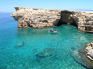
Pano Koufonisi
| Pano Koufonisi | ||
|---|---|---|
| Bay at Pori on Pano Koufonisi | ||
| Waters | Mediterranean Sea | |
| Archipelago | Cyclades | |
| Geographical location | 36 ° 56 '24 " N , 25 ° 36' 36" E | |
|
|
||
| length | 2.8 km | |
| width | 3.5 km | |
| surface | 5.77 km² | |
| Highest elevation | 110 m | |
| Residents | 399 (2011) 69 inhabitants / km² |
|
| main place | Koufonisi | |
The Greek island of Pano Koufonisi ( Greek Πάνω Κουφονήσι ( n. Sg. ) 'Upper Koufonisi') belongs to the island group of the Small Cyclades . Together with another twelve islands and rocky islets, Pano Koufonisi forms the municipality (gr. Dimotiki enotita ) Koufonisia within the municipality of Naxos and the Lesser Cyclades . The main town of the island is the eponymous place Koufonisi with 399 inhabitants.
location
Pano Koufonisi is located about 4 km southeast of Naxos , 22 km northwest of Amorgos and more than 22 km southwest of Donousa . Pano Koufonisi is separated from the southern island of Kato Koufonisi by the approximately 400 m narrow and maximally 8 m deep strait of Koufonisi (Στενό Κουφονησιού) . The also uninhabited island of Glaronisi is about 1200 m south, Keros about 3.8 km southeast.
The sea area between Pano Koufonisi, Kato Koufonisi and Keros was called Kophos Limin ('Κωφὸς Λιμὴν') in ancient times .
history
Tombs of the Bronze Age Cycladic culture from the 3rd millennium BC were found on Pano Koufonisi . Archaeologically proven in three places. At Alonistra Chousouri , Tsavaris and Agrilia , tombs were archaeologically explored in the 1970s.
Pano Koufonisi came after the conquest of Constantinople during the Fourth Crusade to the Venetian Duchy of Archipelagos , which was founded in 1207 by Marco Sanudo . After Chaireddin Barbarossas' fleet conquered Naxos, the Ottoman rule began. The island was a haven for pirates during the Ottoman era.
With the London Protocol of 1829 , Pano Koufonisi, like the other Cyclades islands, became part of the new Greek state. During the Second World War , the island was first occupied by Italy from 1941 to 1943 and then by the German Wehrmacht until 1944 .
According to the 2011 census, 391 inhabitants lived in the port of the same name and 8 in the northeastern coastal town of Finikas. The main occupations are fishing, agriculture, which is only sparse, and tourism, which is now flourishing.
archeology
One of the largest grave fields of the Cycladic culture is located near the main town of the island at Agrilia, which was used for at least 100 years but not for more than 200 years. The cemetery of Agrilia is particularly important for the chronologically correct classification of the Kampos group, which is regarded as an intermediate link between the Grotta-Pelos culture (FK I) and the Keros-Syros culture (FK II). Although badly damaged by robbery excavations, 72 of the at least 92 graves of the necropolis were archaeologically examined. The graves differ from the previously known stone box graves of the Cyclades. These are chamber tombs carved into the stone, separated from a smaller antechamber by a plate. The unusual grave architecture and grave goods such as foot shells and bowls show parallels to the burial ground of Agia Photia in northeast Crete. While the antechambers of the graves on the Cycladic Kampos group did not contain any additions, a foot bowl was found in one case in Agia Photia . In addition, metal objects were found more frequently in Crete. The earliest occurrence of long daggers in the Cyclades could be proven in the cemetery of Agrilia .
natural reserve
Pano Koufonisi is part of the Natura 2000 area GR4220013 Mikres Kyklades: Irakleia, Schinoussa, Koufonisia, Keros, Antikeri kai Thalassia Zoni (Μικρές Κυκλάδες: από Κέρο μέχρι Ηράκλεια, Σχοινούσσα, Κουφονήσια, Κέρος, Αντικέρι και θαλάσσια ζώνη).
Web links
- General information about Pano Koufonisi , (Greek).
- Information about the Little Cyclades, Koufonisi , (Greek).
Individual evidence
- ↑ Results of the 2011 census, Greek Statistical Office (ΕΛ.ΣΤΑΤ) ( Memento from June 27, 2015 in the Internet Archive ) (Excel document, 2.6 MB)
- ↑ Cyprian Broodbank: At Iceland Archeology of the Early Cyclades . Cambridge University Press, 2002, ISBN 0-521-52844-5 , pp. 221 f . (English).
- ↑ Mariya Ivanova: Fortified settlements in the Balkans, in the Aegean Sea and in Western Anatolia, approx. 5000–2000 BC. Chr. Waxmann Verlag, 2008, ISBN 978-3-8309-1937-7 , pp. 74 .


