Amorgos
|
Amorgos municipality Δήμος Αμοργού (Αμοργός) |
||
|---|---|---|
|
|
||
| Basic data | ||
| State : |
|
|
| Region : | South Aegean | |
| Regional District : | Naxos | |
| Geographic coordinates : | 36 ° 50 ′ N , 25 ° 54 ′ E | |
| Area : | 126.346 km² | |
| Residents : | 1,973 (2011) | |
| Population density : | 15.6 inhabitants / km² | |
| Community logo: | ||
| Seat: | Amorgos | |
| LAU-1 code no .: | 6701 | |
| Districts : | no | |
| Local self-government : | 6 local communities | |
| Website: | www.amorgos.net | |
| Location in the South Aegean region | ||
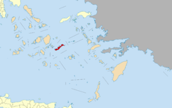
Amorgos ( Greek Αμοργός [ amɔrˈɣɔs ] ( f. Sg. )) Is a Greek Cyclades island in the Aegean Sea . Together with some uninhabited small islands, it forms a municipality (δήμος, dímos ) in the South Aegean region . In 2011 the island had 1973 inhabitants. The administrative seat is the capital of the same name Amorgos, often also called Chora.
geography
Amorgos is the easternmost island in the Cyclades; it is located about 30 kilometers southeast of Naxos and 33 kilometers east of Ios . The Little Cyclades lie in the sea area between Naxos and Amorgos . As the easternmost Cycladic island, Amorgos is a bridge to the Dodecanese . Kinaros is 19 kilometers east, Astypalea about 41 kilometers southeast.
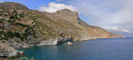
The area of the seventh largest Cycladic island is 121,464 square kilometers. From west-southwest to east-northeast, the island is about 33 kilometers long on the longitudinal axis, the width varies between 1.9 and 6.5 kilometers. The entire length of the island is criss-crossed by a mountain range that drops steeply into the sea along the southeast coast. In the northeast lies a rocky mountain range that is difficult to access, where the island with the Krikellos (Κρίκελλος), more rarely also known as Kroukelos (Κρούκελος), reaches the maximum height of 823 meters. In the middle of the Profitis Ilias (Προφήτης Ιλίας) rises to 698 meters and in the south of the Korakas (Κόρακας) also Vouno tou Choriou (Βόυνο του Χωριού) to 530 meters.

In contrast to the steep and rocky south-east coast, the west of the island is divided by several small gorges in bays with sandy beaches. Only in the coastal plain of Egiali and in the area of Xylokeratidi and Katapola there are alluvial valleys; there the cultivation of field crops and olive tree cultures is possible. In the southwest, the plateau in the hinterland of Kolofana and Kalotaritissa is a traditional growing area for grain and fodder.
Amorgos is an arid island. Small springs can only be found in places where slate predominates. Usually these do not carry water during the summer dry season. The two most important springs on the island are near Chora and Katapola. Ruins of old watermills in their vicinity suggest that larger amounts of water were in earlier times. The island's watercourses only carry water periodically. After the winter rainfall, the torrents dry up during the summer. The largest are the Araklos in the north of the island and the Kato Fylladi near Chora, which flows into the Bay of Katapola as Fonia (Φονιά) .
There are several uninhabited islands off the northwest coast, the total area of which is less than 5 km². The largest is Nicouria (Νικουριά) about 250 meters away; the highest point has a height of 346 meters. Other islands are Gramvousa, Grambonisi, Petalidi and Psalida. Andikeros and Drima lie at a greater distance ; they are assigned to the Small Cyclades .
The island is partly forested. Large quantities of wild herbs such as the Greek oregano grow on Amorgos .
Administrative division
| Local community (Τοπική Κοινότητα) | Greek name | code | Area (km²) | 2001 residents | Residents 2011 | Villages and islands |
|---|---|---|---|---|---|---|
| Amorgos | Τοπική Κοινότητα Αμοργού | 67010001 | 38.009 | 414 | 409 | Chora , Grambonisi , Kastelopetra, Nicouria |
| Egiali | Τοπική Κοινότητα Αιγιάλης | 67010002 | 30.969 | 487 | 514 | Langada, Agios Pavlos, Ormos Egialis, Potamos |
| Arkesini | Τοπική Κοινότητα Αρκεσίνης | 67010003 | 21.020 | 218 | 179 | Arkesini, Gramvousa , Kalotaritissa, Kalofana, Mavri Myti, Rachoula, Felouka , Psalida |
| Vroutsis | Τοπική Κοινότητα Βρούτση | 67010004 | 10,799 | 82 | 87 | Vroutsis, Kamari |
| Tholaria | Τοπική Κοινότητα Θολαρίων | 67010005 | 14,577 | 173 | 189 | Tholaria, Paralia tholarion |
| Katapola | Τοπική Κοινότητα Καταπόλων (Αμοργού) | 67010006 | 10.972 | 485 | 595 | Katapola, Ano Andikeri , Kato Andikeri , Lefkes, Nera, Xylokeratidi, Pera Rachidi, Rachidi, Christoulaki |
| total | 6701 | 126,346 | 1859 | 1973 | ||
history
Already relatively densely populated in prehistoric times, the island was probably already in the 3rd millennium BC. An important trading post; Grave finds with early Cycladic marble idols prove their importance.
Around 1000 BC Chr. To let ionic settlers on Amorgos down in the 7th century. BC Samians under the leadership of the poet Semonides . In the 5th century BC The three Poleis of Amorgos - remnants of the ancient cities Minoa , Arkesine and Aigiale are preserved - joined the Attic League as "Amorgians" while maintaining the political unity . In the naval battle of Amorgos in 322, the Athenian fleet was defeated by the Macedonians, which led to the end of Athens' sea power. Political unity was also lost during the Diadoch Wars , until around 200 BC. BC came under the protectorate of Rhodes again to the amalgamation of the island communities. Fortifications, including a number of watchtowers from Hellenistic and Roman times scattered across the island, prove that Amorgos with its port of Katapola remained an important trading post. The almost transparent Amorgian canvas was made on Amorgos and was used in the 4th and 5th centuries BC. Was known and appreciated as "Amorgian garments". During the Roman Empire, Amorgos was also a place of exile for distinguished Romans. In late antique times, Chora became the main town of the island in a protected altitude above the east coast. There, as in Katapola and Arkesini, early Byzantine church buildings have been proven.

After the Fourth Crusade , the island fell to the Duchy of Naxos in 1207 , but was recaptured by the Byzantine fleet and taken over by Emperor John III. Dukas Batatzes left to his friend Geremia Ghisi. He repopulated the deserted island and fortified the rock "Kastro" towering over the Chora to protect against pirates. Recaptured by Byzantium in 1269, Amorgos was guaranteed possession of the Ghisi in the peace between Venice and Emperor Andronicus II. Palaiologos in 1303 . As early as 1309, however, Duke Guglielmo I of Naxos took possession of the island and handed it over to the Schiavi of Ios and half to the Grimani , who already owned part of Astypaleas . Pirate attacks displaced many residents who then moved to the Venetian Crete.
With the conquest by Chaireddin Barbarossa , the Ottoman rule began on the island (1537-1830). During the Russo-Turkish war , Amorgos was occupied by the Russian fleet. During the Greek Wars of Liberation , refugees from the island of Kassos found admission to Amorgos.
On July 9, 1956, a seaquake measuring 7.8 on the Richter scale occurred in the Aegean Sea south of Amorgos . The resulting tidal wave was about 20 m high on Amorgos on the south coast near Mouros. Some internet sources claim that there were 53 deaths on Amorgos and that numerous houses were destroyed. Since the south coast of Amorgos is steep and completely uninhabited, but the tsunami on the north coast only reached a maximum height of 2 meters, these figures can be doubted. What is probably meant is the total number of dead in the Aegean.
Attractions
The most important attraction of Amorgos is the rock monastery Panagia Chozoviotissa ( Greek Παναγία Χοζοβιώτισσα ) on the steep slope of the Profitis Ilias summit, 300 m above sea level; It is considered to be one of the most architecturally interesting monasteries in the Aegean and is often compared to the Meteora monasteries.
The monastery is said to have been founded by monks from Palestine at the beginning of the 9th century. The legend creates a connection with the Byzantine iconoclasm : a pious woman from Chosovo in Palestine is said to have thrown an icon into the sea to save it from destruction. In the bay of Agia Anna on Amorgos, the icon of Our Lady - named Panagia Chozoviotissa after its place of origin - was washed ashore. The monastery, built on the rocky slope above the bay, was destroyed by pirates and re-established and rebuilt in the 11th century by Emperor Alexios I Komnenos ; the year of the re-establishment is given as 1088.
The monastery still preserves parchment manuscripts from the 11th to 13th centuries. Until the 19th century Chozoviotissa was one of the richest monasteries in Greece; however, the Greek state expropriated the lands in 1952 and handed them over to the municipalities.
In the 1990s, the monastery achieved cinematic fame through the film Im Rausch deriefe by Luc Besson , which was largely filmed on Amorgos.
From 1966 to 1977 Iannis Xenakis built a holiday home for himself on the island. The organic building is one of the few realizations of the architect who has become famous as a composer and represents a special interpretation of Cycladic architecture .
literature
- Dirk Schönrock: Amorgos and small Ostkykladen . 1997, ISBN 3-932410-09-2 .
Web links
- Official website of the municipality (English).
Individual evidence
- ↑ Results of the 2011 census, Greek Statistical Office (ΕΛ.ΣΤΑΤ). ( Memento from June 27, 2015 in the Internet Archive ). (Excel document; 2.6 MB).
- ↑ Ελληνική Στατιστική Αρχή [ΕΛΣΤΑΤ] (Ed.): Στατιστική Επετηρίδα της Ελλάδος (Statistical Yearbook of Greece) 2009 & 2010 . Piraeus 2011, p. 47 .
- ↑ Map 10.27, Αμοργός Amorgos, 1: 25,000 . Anavasi, Athens, ISBN 960-8195-31-4 .
- ↑ Kaletsch: Amorgos . In: Lauffer (Ed.): Greece. Lexicon of Historic Places .
- ↑ Emile Okal, Costas Synolakis, Burak Uslu, Nikos Kalligeris, Evangelos Voukouvalas: The 1956 earthquake and tsunami in Amorgos, Greece. In: Geophysical Journal International. Number 178, Oxford University Press, 2009, p. 1539. (PDF; 2.5 MB).


