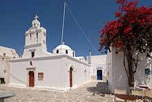
Andiparos
|
Andiparos municipality Δήμος Αντιπάρου (Αντίπαρος) |
||
|---|---|---|
|
|
||
| Basic data | ||
| State : |
|
|
| Region : | South Aegean | |
| Regional District : | Paros | |
| Geographic coordinates : | 37 ° 0 ′ N , 25 ° 3 ′ E | |
| Area : | 45.182 km² | |
| Residents : | 1,211 (2011) | |
| Population density : | 26.8 inhabitants / km² | |
| Seat: | Andiparos | |
| LAU-1 code no .: | 6802 | |
| Districts : | no | |
| Local self-government : | no | |
| Website: | www.antiparos.gr | |
| Location in the South Aegean region | ||
Andiparos ( Greek Αντίπαρος ( f. Sg. ), Transcr. Also Antiparos, ancient Greek Ωλίαρος Ōliaros ) is a small Greek island in the Aegean Sea , which belongs to the Cyclades archipelago . The name is derived from the location of the island ( andi- 'opposite', Paros ' Paros '). Together with some uninhabited islets, including Despotiko and Strongyli , it forms a municipality in the South Aegean region .
The 35.090 km² island is separated from its large sister island Paros by a narrow 1.5 km wide strait ; Andiparos can be reached by a 10- to 15-minute ferry connection from the port of Pounda or an approx. 30-minute boat connection (but only in summer) from the main town Parikia on the neighboring island of Paros. The highest point of the approximately 12.5 km long and up to 5.5 km wide island is the Profitis Ilias at 300 m .
In the north of the strait between Andiparos and Paros are several islands that have remained from the land connection that existed until the Byzantine period and has since been flooded by the rising sea level. The oldest known settlement in the Cyclades from the Neolithic Age (around 4800 BC) was found on the island of Saliagos , which is only 100 × 50 m in size . The island of Strongylonisi is only inhabited today . It belongs to the well-known shipowner family Goulandris from Andros .
population
Almost all residents of the island live in the main town of the same name with a few shops and taverns on the road leading to the "Kastro" - the castle built in 1440 - and the quiet sandy beach on the west side of the island. The main attraction is the stalactite cave, which can be reached by bus or on foot from the pier, and is reached via a 90 m stepped path.
| Surname | Greek name | 1920 | 1928 | 1940 | 1951 | 1961 | 1971 | 1981 | 1991 | 2001 | 2011 |
|---|---|---|---|---|---|---|---|---|---|---|---|
| Andiparos | Αντίπαρος ( f. Sg. ) | 437 | 612 | 606 | 680 | 631 | 538 | 635 | 775 | 979 | 1102 |
| Agios Georgios | Άγιος Γεώργιος ( m. Sg. ) | * | 11 | 31 | 25th | ||||||
| Cambos | Κάμπος ( m. Sg. ) | * | 14th | 13 | 49 | ||||||
| Soros | Σωρός ( m. Sg. ) | 19th | 14th | 35 | |||||||
| total | 543 | 612 | 606 | 680 | 631 | 538 | 635 | 819 | 1037 | 1211 | |
* 1913: for Kambos and Agios Georgios a total of 106 inhabitants are given.
The municipality of Andiparos includes the uninhabited islands of Despotiko , Diplo, Kavouras, Revmatonisi, Strongyli and Tsimindiri.
Web links
Individual evidence
- ↑ a b Results of the 2011 census, Greek Statistical Office (ΕΛ.ΣΤΑΤ) ( Memento from June 27, 2015 in the Internet Archive ) (Excel document, 2.6 MB)
- ↑ Ελληνική Στατιστική Αρχή [ΕΛΣΤΑΤ] (Ed.): Στατιστική Επετηρίδα της Ελλάδος (Statistical Yearbook of Greece) 2009 & 2010 . Piraeus 2011, p. 47 .
- ↑ Population of Andiparos 1920–2001, Greek Statistical Office ELSTAT, Digital Library (Greek)


