
Anafi
|
Municipality of Anafi Δήμος Ανάφης (Ανάφη) |
|||
|---|---|---|---|
|
|||
| Basic data | |||
| State : |
|
||
| Region : | South Aegean | ||
| Regional District : | Thira | ||
| Geographic coordinates : | 36 ° 22 ′ N , 25 ° 47 ′ E | ||
| Area : | 40.370 km² | ||
| Residents : | 271 (2011) | ||
| Population density : | 6.7 inhabitants / km² | ||
| Seat: | Anafi | ||
| LAU-1 code no .: | 6002 | ||
| Districts : | no | ||
| Local self-government : | no | ||
| Location in the South Aegean region | |||
 |
|||

Anafi ( Greek Ανάφη ( f. Sg. )) Is a small island in the southeast of the Cyclades with 294 inhabitants (2011). Together with a few uninhabited islets, it forms a municipality in the South Aegean region of Greece . With a length of 12 km and a width of 6 km, it has a surface of 38.636 km² and rises to 582 meters above sea level. d. M.
history
According to mythological tales, Apollo is said to have ordered Anafi to emerge from the sea in order to save the Argonauts from a storm on their journey from Colchis and to give them protection.
According to ancient tradition, Phoenicians first settled here , later Dorians who founded a town on Mount Kastelli.
In the 5th century BC Anafi belonged to Athens , in the Middle Ages to Naxos and several Venetian families.
In 1537 the island was conquered by the Turks, until it became part of the newly founded state of Greece in 1830.
| Surname | Greek name | 1920 | 1928 | 1940 | 1951 | 1961 | 1971 | 1981 | 1991 | 2001 | 2011 |
|---|---|---|---|---|---|---|---|---|---|---|---|
| Anafi | Ανάφη ( f. Sg. ) | 558 | 565 | 785 | 532 | 471 | 353 | 285 | 261 | 269 | 256 |
| Klisidi | Κλησίδι ( n. Sg. ) | - | - | 2 | 12 | ||||||
| Ormos Agiou Nikolaou | Όρμος Αγίου Νικολάου ( m. Sg. ) | 7th | - | 2 | 3 | ||||||
| total | 559 * | 565 | 785 | 532 | 471 | 353 | 292 | 261 | 273 | 271 | |
* 1920: for Moni Kalamiotissis 1 resident
The uninhabited islands of Makra, Pachia and Ftena belong to the municipality of Anafi.
Attractions
Today there is a port (Agios Nikolaos) on Anafi, above it a village (Chora) and along the south coast seven sandy beaches (including Klisidi, Katsouni, Mikros and Megalos Roukounas as well as Prassies), to the east of the tall marble monolith Kalamos, at its foot Zoodochos Pigi Monastery is located. Kalamos is the second highest rock in Europe after Gibraltar. The church of Panagia Kalamiotissa is enthroned on the rock.
About half of the island is owned by the Orthodox Church . A bus goes to the beaches several times a day in summer. Near the village there is a Venetian castle and the church of Agios Athanasios.
Further to the east there are Greek and Roman ruins, some of which are under water and sometimes flooded free during storms in winter.
Anafi is served several times a week by ferries from Santorini, the crossing takes about two hours.
Up until a few years ago there was a single road connecting the port to the village, on which a bus ran. In the meantime, more roads have been built, for example to the monastery at the foot of the Kalamos in the southwest of the island, making the numerous beaches on the south coast much easier to reach, as well as from Chora to the west and from Chora to the interior of the island.
On Anafi there is a post office, a doctor and a heliport .

Anafi village from above
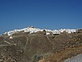
The chora
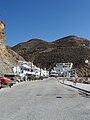
Agios Nikolaos port

South coast with the Kalamos monolith
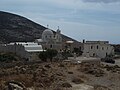
Zoodochos Pigi at the foot of the Kalamos

View of the island from the Panagia Kalamiotissa complex
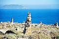
Stone men with a view of the offshore island of Pachia


Web links
Individual evidence
- ↑ a b Results of the 2011 census, Greek Statistical Office (ΕΛ.ΣΤΑΤ) ( Memento from June 27, 2015 in the Internet Archive ) (Excel document, 2.6 MB)
- ↑ Ελληνική Στατιστική Αρχή (Ed.): Στατιστική Επετηρίδα της Ελλάδος (Statistical Yearbook of Greece) 2009 & 2010 . Piraeus 2011, p. 47 .
- ↑ Population of Anafi 1920–2001, Greek Statistical Office ELSTAT, Digital Library (Greek)