Peron Peninsula
| Peron Peninsula | ||
 The Shell Beach on the Peron Peninsula |
||
| Geographical location | ||
|
|
||
| Coordinates | 26 ° 6 ′ S , 113 ° 40 ′ E | |
| Waters 1 | Shark Bay | |
| length | 130 km | |
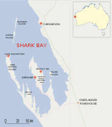
The Peron Peninsula is an elongated peninsula that lies in Shark Bay in Western Australia .
It is 130 km long and extends north-west from Henri Freycinet Harbor and west to Hamelin Pool Marine Nature Reserve and Faure Island .
location
It is the largest peninsula in Shark Bay, on which the Denham and Monkey Mia settlements are located. There is also an airport, Shark Bay Airport . The Peron Peninsula is the area of the early settlers of the Peron and Nanga stations.
The Peron Peninsula is an important part of the Shark Bay World Natural Heritage . The north-lying area of the peninsula includes the François Peron National Park , which is surrounded by the Shark Bay Marine Park and connected in the high, southeastern part to the Hamelin Pool Marine Nature Reserve .
The narrowest part of the peninsula is between Nanga and Goulet Bluff; there is Shell Beach , which is on the eastern side in L'Haridon Bight .
The northernmost point of the peninsula is Cape Peron , which should not be confused with Cape Peron near Perth .
history
The peninsula is named after the natural scientist François Péron , who reached this area with the Baudin expedition between 1801 and 1803. The peninsula was used for sheep farming from 1880 until the land was bought by the government in 1990.
Peron Homestead Artesian Bore
The Peron Historical Homestead with a visitor center is located near Denham. The Peron Peninsula is part of the Carnarvon Basin, a geological sedimentation basin that is filled with fresh water. During the early 1900s, drilling was carried out to obtain a larger and better quality water supply. The artesian water obtained was 35-60 ° C and had a high salt and mineral content.
literature
- Edinburgh Journal of Natural and Geographical Science (1830): Account of Peron's Peninsula, in Shark's Bay, Western Australia . Pp. 249-257
- Carolyn Thomson: Discovering Shark Bay Marine Park and Monkey Mia . Como, WA Department of Conservation and Land Management. 1997. ISBN 0-7309-6854-5
Individual evidence
- ↑ Australia Tourism website ( Memento of September 21, 2009 in the Internet Archive ). Retrieved January 5, 2020


