
Petersbach (Mur)
| Petersbach | ||
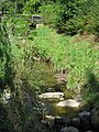
 Headwaters of the Petersbach at the foot of the Lustbühel |
||
| Data | ||
| location | Graz , Styria , Austria | |
| River system | Danube | |
| Drain over | Mur → Drava → Danube → Black Sea | |
| source | at the foot of the Lustbühel 47 ° 4 ′ 4 ″ N , 15 ° 29 ′ 53 ″ E |
|
| Source height | 422 m above sea level A. | |
| muzzle | north of the Puntigamer bridge in the Mur Coordinates: 47 ° 2 ′ 12 " N , 15 ° 26 ′ 45" E 47 ° 2 ′ 12 " N , 15 ° 26 ′ 45" E |
|
| Mouth height | 333 m above sea level A. | |
| Height difference | 89 m | |
| Bottom slope | 14 ‰ | |
| length | 6.4 km | |
| Catchment area | 12.17 km² | |
The Petersbach is a brook in the Graz districts of St. Peter and Liebenau .
The Petersbach rises in a swamp area at the foot of the Lustbühel and flows southeast towards the Mur , into which it flows north of the Puntigamer Bridge. The most important tributary of the Petersbach is the right feeder from the Paierlhang, which joins at the intersection of Peterstalstraße and Weiherweg .
In addition to the Andritzbach and the Schöckelbach , the Petersbach is the most flood-prone city of Graz. The areas at risk of flooding extend along Peterstalstrasse and Banngrabenweg. One problem area is St. Peter Hauptstrasse , where the Petersbach runs 450 meters below the road. In recent times there have been several major floods because of the bank zone construction with a discharge capacity of only 2 m³ per second - a flood of the century is calculated at 16 m³ per second.
gallery
Petersbach middle course at the level of Petersbachstraße
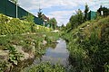
Stream on the Banngrabenweg


Web links
- Petersbach. In: "Grazer Brooks' program of measures 2006" (PDF; 4.4 MB)
- City of Graz "WebGIS brooks in Graz", interactive map
- Information brochure "Flood Protection Petersbach" (PDF; 4.9 MB)
Individual evidence
- ↑ Extract from the digital Styrian body of water index. State of Styria , accessed on December 16, 2017 .
- ↑ BMLFUW (ed.) : List of areas of the Austrian river basins: Mur area. In: Contributions to Austria's Hydrography Issue No. 60, Vienna 2011, p. 76. PDF download , accessed on July 6, 2018.