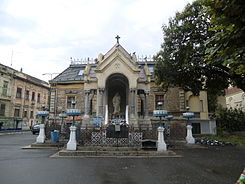
Piața Sfânta Maria
| Piața Sfânta Maria | |
|---|---|
| Place in Timișoara | |
 The Piața Sfânta Maria, 2007 |
|
| Basic data | |
| place | Timișoara |
| District | Elisabeth |
| Confluent streets | Bulevardul 16 Decembrie 1989, Strada Gheorghe Doja |
| Buildings | Statue of Saint Mary |
The Piața Sfânta Maria (until 1993 Piața Sfînta Maria , German: Place of Saint Maria ), also Piața Maria or colloquially called at Maria or Maria , is a place in Timișoara . It has the shape of a right-angled trapezoid and is located on the edge of the Elisabetin district , in the corner between Bulevardul 16 Decembrie 1989 and Strada Gheorghe Doja. The name of the square is not shown on city maps, but Piața Sfânta Maria is an official stop designation of the local transport company . There is also a corresponding street sign on site .
history
Long before the Piața Sfînta Maria was built, a cross in honor of the peasant leader Gheorghe Doja, who was executed there in 1514, existed on the former overland road from the district of Cetate to the district of Iosefin . From this, the present statue of St. Mary emerged in 1906 , which gave the square its name in later years. The square itself was built in the second half of the 1890s, when Strada Gheorghe Doja (then Dózsa utcza ) was built as a connecting road between Piața Nicolae Bălcescu and Bulevardul on 16 Decembrie 1989 (then Hunyadi út ) in the course of the increasing development of the former fortress foothills . The Reformed Church, completed in 1902, and the Strada Gheorghe Doja number 2 building, which was built around the same time, finally completed the square ensemble. As early as 1899, the square was also a junction of the then newly opened electric tram , whose passengers at Piața Sfânta Maria could change from the main lines I and II to the branch line IV. In December 1989 the Romanian Revolution finally began on the Piața Sfânta Maria, where the first demonstrations took place.
Individual evidence
- ↑ ratt.ro
- ↑ timisoreni.ro
- ↑ 60 de ani de la înființarea tramvaiului în Timișoara, monograph 1869–1929 . Timișoara 1929.
Coordinates: 45 ° 44 '53.9 " N , 21 ° 13' 7.8" E