
Iosefin


Iosefin ( German Josefstadt , Hungarian Józsefváros ) is a historic quarter and the IVth district of the western Romanian city of Timișoara . The spellings Iozefin , Jozefin or Josefin are also occasionally used. The district occupies an area of 442 hectares.
history
The district was founded in 1744 at the gates of the Temeschburg Fortress . Initially, summer residences with lush gardens for well-off citizens, mostly of German origin, were built here, which were called Neue Mayerhöfe ( Romanian Maierele Noi ) or Neue Deutsche Mayerhöfe ( Hungarian Új Német Majorok ). The place name was a demarcation to the neighboring and a little earlier created Alten Mayerhöfe , today's Elisabethstadt .
The nucleus of the settlement was the area between today's streets Strada Gării in the north, Strada General Ion Dragalina in the east, Bulevardul Regele Carol I in the south and Strada Pop de Băseşti in the west. Like many Banat towns, Josefstadt is not a historically grown cluster village , but was planned on the basis of a largely rectangular structure. The canalization of the Bega between 1727 and 1733 was a prerequisite for the settlement of the area .
1,773 were new Mayer courtyards in honor of Emperor Joseph II. , The incognito as Count von Falkenstein in the same year, the Banat had traveled in Josefstadt renamed, then in the 19th century suburb Josefstadt called (also written with ph instead of f). After the Austro-Hungarian Compromise of 1867, the district was named Józsefkülváros ( German Josefvorstadt or suburb Josefstadt ), which was simplified to Józsefváros around the turn of the century . As a result of the Treaty of Trianon , it was then given its current Romanian name Iosefin in 1920 . However, in the interwar period, the district was sometimes called Principele Carol , named after Charles I of Romania . In the socialist era , the city district was temporarily called May 1, based on the day of the labor movement .
The importance of Josefstadt grew with the advancing industrialization . The district owes this development to its favorable location on the navigable part of the Bega Canal. Milestones in this development were the tobacco factory completed in 1848, the Timișoara Nord train station opened in 1857 (expanded in 1899, today part of the neighboring district of Mehala ) and the lamp oil factory. The city harbor was also laid out in Josefstadt. By the end of the 19th century, most of the areas were built on, and the boundaries to the neighboring district of Elisabethstadt to the east were barely noticeable in terms of urban development.
Buildings and structures
Iosefin extends over both sides of the Bega Canal. Many buildings in the district, especially along the Bega, are in the Viennese Secession style and date from around 1900. On today's Bulevardul General Ion Dragalina , the former "Herrengasse", some of the old Wilhelminian style prefabricated buildings had to give way during the communist era . The most important parks are Parc Alpinet and Parc Doja . In contrast to most of the other Timișoara districts, the historical Josefstadt is administratively not divided into further districts or residential areas. However, mainly in the 1970s, numerous new development areas with their own names (but without an administrative function) emerged on the southern edge of Josefstadt. They are called Cartier Dâmbovița, Calea Șagului Vest I, Calea Șagului Vest II and Zona Steaua.
Sacred buildings
- the Roman Catholic parish church of the Nativity of Mary , Biserica romano-catolică din Iosefin , built in 1774 in the Baroque style, is one of the oldest sacred buildings in Timisoara. In her churchyard there is a stone figure of St. Nepomuk from 1723.
- the Roman Catholic monastery church Notre Dame “Birth of the Blessed Virgin Mary” , Biserica Notre Dame from the late 19th century, Church of the Poor School Sisters Notre Dame
- the synagogue in Josefstadt , Sinagoga din Iosefin

The Roman Catholic Parish Church of the Birth of Mary, 2002

The Roman Catholic monastery church Notre Dame "Birth of the Blessed Virgin Mary", 1910
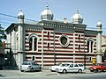
The synagogue in Josefstadt, 2008


bridges
Six bridges cross the Bega in Iosefin, they are:

Podul Traian, 1906

Podul Ştefan cel Mare, around 1900

Podul Eroilor, then Bem-híd, looking upstream, around 1900


Other buildings
- Hat factory
- Tobacco factory
- Water tower near the Podul Muncii, built in 1914
- Casa cu Ancoră ( German House of the Anchor ) was built in 1755 and was the seat of the port commander.
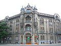
- Palat pe splaiul Tudor Vladimiresc, the administrative building of Regionala CFR
- Fire station built by László Székely

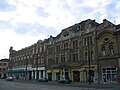
Row of buildings on the left bank of the Bega
Bulevardul December 16, 2008
Building in Iosefin


various
Because of the same background to the naming, Iosefin forms the federation of Josefstadt with the districts Josefstadt in Vienna and Józsefváros in Budapest .
literature
- Dan N. Buruleanu, Florin Medeleț: Timișoara povestea orașelor sale = Timişoara the history of a city . Editura Mirton, Timișoara 2004, ISBN 973-661-275-9 (German, Romanian).
- Mihai Opriș : Timișoara. Urbanisticã monograph, vol. I . Editura Bruma, 2007, ISBN 978-973-602-245-6 . , in Romanian
- Else von Schuster, illustrated by Lia Popescu: A tour of Timisoara . ADZ , 1996, ISBN 973-97541-3-9 , pp. 28 .
Web links
- parohiaiosefin.ro , Parohia Iosefin. in Romanian language
- derstandard.at , Der Standard , Martin Putschögl: Revolution in the Josefstadt. March 30, 2009
- timisoara.org , Historical Timișoara and its monuments. in English
- Kulturraum-banat.de , Franz Engelmann, Hans Gehl : Old districts.
Individual evidence
- ^ The urban geography of Timisoara
- ^ Martin Putschögl: Revolution in the Josefstadt. In: derstandard.at , Der Standard , March 30, 2009, accessed on May 27, 2011.
Coordinates: 45 ° 44 ′ 39.5 ″ N , 21 ° 12 ′ 27.2 ″ E
