
Piedipaterno
| Piedipaterno | |||
|---|---|---|---|

|
|||
| View of Piedipaterno | |||
| Country | Italy | ||
| region | Umbria | ||
| province | Perugia (PG) | ||
| local community | Vallo di Nera | ||
| Coordinates | 42 ° 46 ' N , 12 ° 52' E | ||
| height | 333 m slm | ||
| Residents | 133 (2011) | ||
| Telephone code | 0743 | CAP | 06040 |
Piedipaterno is a district ( fraction , Italian frazione ) of the Italian municipality Vallo di Nera in the province of Perugia in Umbria .
geography
The place is about 1.5 km north of the capital Vallo di Nera and about 55 km southeast of the provincial and regional capital Perugia . The place is at 333 m slm and had about 117 inhabitants in 2001. In 2011 there were 133 residents. The place is on the river Nera .
history
The place was first mentioned in the 14th century and arose at the foot (Italian: Piede ) of Paterno , a fortified place at 605 m slm about 650 m north and above Piedipaterno. The place, created as a trading post of the castle on the roads to Cerreto di Spoleto and Spoleto , became more important when the castle lost its importance after the revolt of the local castles against Spoleto in the 1520s. In 1833 the place was merged with Meggiano to form the Comunità di Meggiano e Paterno and from 1880 onwards it was called Piedipaterno sul Nera . Piedipaterno has been part of Vallo di Nera since May 13, 1881. From 1926 to 1968 the place had the stop Piedipaterno-Vallo di Nera on the Spoleto- Norcia railway line , which was closed in 1968.
Attractions
- San Sebastiano , church in the town center, which was built above the Chiesa di San Costanzo , documented in 1253 , and which belonged to the Abbazia di Sant'Eutizio abbey near Preci . San Sebastiano became a parish church in 1654 when the church took over the functions of the Abbey of Santa Maria dell'Eremita (located about 2 km north). Contains the canvas painting Madonna con Bambino in Trono from the 13th century, a baptismal font from 1603 and a wooden altar from the 17th century.
- San Pietro , church on the Nera river. Contains two frescoes from the late 16th century ( Madonna con Bambino and Santo Vescovo ). Above the portal is the inscription AGREGATA BASILIC / E S. PETRI URBIS AD LUCRANDAS INDULGENTIA AD MDCCLXII (1762). In 1712 the church was still dedicated to Maria della Pietà.
- Chiesa dell'Eremita (also Santa Maria de Ugonis ), former abbey on the road to Cerreto di Spoleto, which was built in the 9th century and re-founded by the Vallombrosans in the 11th century . The resolution found in 1654 by Pope Innocent X instead.
- Images by Piedipaterno

The Church of San Sebastiano

The Church of San Pietro on the Nera River
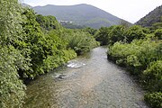
The Nera River at Piedipaterno

The Torre di Paterno


Web links
Individual evidence
- ↑ a b Official website of ISTAT ( Istituto Nazionale di Statistica ) on 2001 population figures in the province of Perugia, accessed on November 6, 2019 (Italian)
- ↑ Italia in dettaglio
- ↑ a b c d I Luoghi del Silenzio: Piedipaterno - Vallo di Nera (PG).
- ^ Sistema Informativo Unificato per le Soprintendenze Archivistiche: Comune di Meggiano e Paterno. Retrieved November 6, 2019 (Italian)
- ^ Ferrovie volume on: Ferrovia Spoleto FS - Norcia. Retrieved November 6, 2019 (Italian)
- ↑ La Valnerina: I Luoghi del Sacro: Chiesa dell'Eremita, già dedicata a Santa Maria de Ugonis. Retrieved November 6, 2019 (Italian)