
Cerreto di Spoleto
| Cerreto di Spoleto | ||
|---|---|---|

|
|
|
| Country | Italy | |
| region | Umbria | |
| province | Perugia (PG) | |
| Coordinates | 42 ° 49 ′ N , 12 ° 55 ′ E | |
| height | 557 m slm | |
| surface | 74.79 km² | |
| Residents | 1,012 (Dec. 31, 2019) | |
| Population density | 14 inhabitants / km² | |
| Post Code | 06040 | |
| prefix | 0743 | |
| ISTAT number | 054010 | |
| Popular name | Cerretani | |
| Patron saint | San Nicola ( Pentecost ) | |
| Website | Cerreto di Spoleto municipality | |
 Panorama of Cerreto di Spoleto |
||

Cerreto di Spoleto is an Italian commune with 1012 inhabitants (as of December 31, 2019) in the province of Perugia in the Umbria region .
geography
The community extends over around 75 km² . The municipality is located about 60 km southeast of Perugia on the rivers Nera , Corno , Tissino and Vigi on the hill San Sebastiano on the opposite side of Monte Maggiore (1428 m), separated by the Vigital ( Valle del Vigi ) and near the Monte Galloro (1209 m), Monte Motillo (708 m) and Monte Lo Stiglio (864 m). The municipality is in the climatic classification of Italian municipalities in Zone E, 2 355 GR / G.
The neighboring municipalities are Campello sul Clitunno , Cascia , Norcia , Poggiodomo , Preci , Sellano , Vallo di Nera and Visso (MC) .
Districts
The districts include:
- Borgo Cerreto , district at 357 m slm directly below the historic old town (557 m) at the confluence of the Nera and Vigi.
- Bugiano , also spelled Buggiano or called Il Contado (The County). The district was created in the 16th century on the Vigi River and suffered damage from an earthquake in 1979.
- Nortosce , district with a castle from the 13th century at 851 m slm
- Ponte , district at 441 m slm Comes from the time of the Lombards as a watch over the Neria valley . The name comes from a Roman bridge.
- Rocchetta or Rocchetta di Cerreto , district in the Ticino valley (Valle del Tessino, partly also called Tissino ) at 793 m slm The place name comes from the term Rocca (fortress or castle), the fortress itself was also called Rocca Oddi in the past .
- Triponzo , district at the confluence of the Nera and Corno rivers with a castle from the 13th century.
history

The place was created by the Roman Republic and the legions of Manius Curius Dentatus around 290 BC. In the time of the Lombards, the Cerreto Gastalde became what is now the district of Ponte. To protect against the Saracens , the place submitted to the Counts of Spoleto in 1221 . At this time the castle (Castello) was built in today's old town. To separate from Spoleto, Cerreto turned to Francesco I. Sforza together with the town of Ponte in 1442 , but independence was prevented by the Papal States with the help of Niccolò Piccinino . In the following years the place was in permanent conflict with Norcia and remained with the Papal States until 1569. Then the parish was administered by Norcia. Due to the Napoleonic occupation, the administration was briefly returned to Spoleto, after which the place became an independent municipality. After the unification of Italy , the population increased from approx. 1900 to over 2300 inhabitants in 1921, after which the place experienced a population decline, which is currently around 1200 inhabitants.
Origin of names and nicknames
The place name Cerreto comes from the word Cerro , which refers to the Turkey oak in the local coat of arms . In addition, the place claims to be the origin of the word charlatan . The origin of the term can be traced back to a fusion of the demonym Cerretani and the old Italian word ciarlare ("to chat").
Attractions
In the town center

- Torre Campanaria , Campanile and later clock tower at the highest point of the place. Was built in 1452, the clockwork was installed in 1565. The height of the structure is 21 meters.
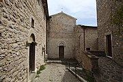
- Chiesa di Santa Maria Annunziata , church in the main town, which was built in 1517 over a church that already existed in the 13th century. The stone portal was built in 1592. Contains the canvas painting Madonna del Rosario by Felice Damiani ( Gubbio , 1560–1608) and a holy water font from 1668.
- Chiesa di San Giacomo , also Monastero di San Giacomo , church and monastery in the lower part of the main town of Cerreto Alto. Originated in the 13th century and is today the seat of the organization CEDRAV (Centro per la Documentazione e la Ricerca Antropologica in Valnerina).
- Chiesa di Santa Maria Delibera , church on the western slope of the old town. Contains the canvas painting "Madonna col Bambino con i Santi Antonio Abate e Lucia" by Felice Damiani from 1581.
- San Nicola Church from the 13th century, now in ruins.
- Palazzo Argentieri , 18th century palace of the Scarduzzi family.
- Palazzo Bonifazi , 17th century building in Piazza Pontano .
- Palazzo Comunale , former town hall from the 16th century.
- Palazzo Comunale , today's town hall, was built in the 19th century on the site of the old castle.
- Palazzo Orlandini , 17th century palace.
- Palazzo Nobili , 17th century.
- Palazzo Toni , 16th century.
- Palazzo Vespasiani , 18th century.

The parish church of Santa Maria Annunziata
The Church of San Giacomo

The Church of Santa Maria Delibera
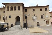
The old City Hall


In the districts


- Chiesa di San Lorenzo , church on the banks of the Nera in the district of Borgo Cerreto, which was built in the 13th century and was named after Francis of Assisi (San Francesco) until 1804 .
- Chiesa di San Paterniano , church on the rocky promontory between Cerreto Alto and Borgo, of which only the sacristy and presbytery remain today.
- Chiesa San Giovanni Battista , church in the district of Bugiano, 12./13. Century.
- Santuario della Madonna del Monte , sanctuary in Fergino, 14th century.
- Chiesa della Madonna Addolorata , church in the Macchia district, 17th century.
- Chiesa di San Pietro , church in the district Nortosce from the 14th century.
- Chiesa di Santa Maria di Ponte , also called Chiesa di Santa Maria Assunta , Pieve in the district of Ponte, which was built in the 12th century.
- Chiesa di San Giacomo , church in the Rocchetta district from the 14th century.
- Chiesa di Santa Maria del Verde , church in the Rocchetta district.
- Chiesa di Santa Caterina , church from the 14th century in the district of Triponzo.
- Madonna delle Grazie , church in the district of Triponzo.
- Convento della Madonna di Costantinopoli , ex-monastery from 1692.
- Eremo della Madonna della Stella , Hermitage at the foot of the Monte Maggio mountain , which was partially carved into the rock and was abandoned by the Augustinian monks as early as 1630.
Sons and daughters of the church
- Antonio Buoncristiani (* 1943), Archbishop of Siena from 2001 to 2019.
- Giovanni Pontano (1429–1503), representative of Italian humanism in the 15th century.
- Ludovico Pontano (1409–1439), lawyer
literature
- TCI : Umbria. Milan 1999, ISBN 88-365-2542-3 , p. 462 f.,
Web links
- Official website of the Municipality of Cerreto di Spoleto (Italian)
- Dates and information about Cerreto di Spoleto at Comuni Italiani (Italian)
- cerretodispoletoturismo.it - Associazione dei Comuni della Valnerina (Italian)
- Website district Rocchetta (Italian)
Individual evidence
- ↑ Statistiche demografiche ISTAT. Monthly population statistics of the Istituto Nazionale di Statistica , as of December 31 of 2019.
- ↑ http://www.comune.cerretodispoleto.pg.it/index.php?area=main&module=contents&contentid=163 - Official website of the municipality of Cerreto di Spoleto on the history of the place, accessed on May 20, 2011, no longer available
- ↑ Bella Umbria website , accessed July 6, 2019 (Italian)
- ^ Official website of the Duden on the word Scharlatan , accessed on July 6, 2019
- ^ I luoghi del silenzio: Chiesa di San Nicola - Cerreto di Spoleto , accessed on July 6, 2019 (Italian)

Assisi | Bastia Umbra | Bettona | Bevagna | Campello sul Clitunno | Cannara | Cascia | Castel Ritaldi | Castiglione del Lago | Cerreto di Spoleto | Citerna | Città della Pieve | Città di Castello | Collazzone | Corciano | Costacciaro | Deruta | Foligno | Fossato di Vico | Fratta Todina | Giano dell'Umbria | Gualdo Cattaneo | Gualdo Tadino | Gubbio | Lisciano Niccone | Magione | Marsciano | Massa Martana | Monte Castello di Vibio | Monte Santa Maria Tiberina | Montefalco | Monteleone di Spoleto | Montone | Nocera Umbra | Norcia | Paciano | Panicale | Passignano sul Trasimeno | Perugia | Piegaro | Pietralunga | Poggiodomo | Preci | San Giustino | Sant'Anatolia di Narco | Scheggia e Pascelupo | Scheggino | Sellano | Sigillo | Spello | Spoleto | Todi | Torgiano | Trevi | Tuoro sul Trasimeno | Umbertide | Valfabbrica | Vallo di Nera | Valtopina