Bastia Umbra
| Bastia Umbra | ||
|---|---|---|

|
|
|
| Country | Italy | |
| region | Umbria | |
| province | Perugia (PG) | |
| Coordinates | 43 ° 4 ' N , 12 ° 33' E | |
| height | 202 m slm | |
| surface | 27.62 km² | |
| Residents | 21,714 (Dec 31, 2019) | |
| Population density | 786 inhabitants / km² | |
| Post Code | 06083 | |
| prefix | 0575 | |
| ISTAT number | 054002 | |
| Popular name | Bastioli | |
| Patron saint | San Michele Arcangelo (September 29th) | |
| Website | Bastia Umbra municipality | |
 Panorama of Bastia Umbra |
||
Bastia Umbra is an Italian commune with 21,714 inhabitants (as of December 31, 2019) in the province of Perugia in the Umbria region .
geography
The community extends over approx. 28 km² . It is located about 150 kilometers southeast of Florence and about 15 kilometers southeast of the regional and provincial capital Perugia at the confluence of the Chiascio and Tescio rivers in the climatic classification of Italian communities in Zone D, 1994 GR / G.
The districts include Bastiola , Cipresso , Costano (191 m, approx. 800 inhabitants), Madonna Campagna (196 m, approx. 230 inhabitants), Ospedalicchio (199 m, approx. 1100 inhabitants), San Lorenzo and Vicinato (with Vicinato le Basse, 203/190 m, approx. 220 inhabitants).
The neighboring municipalities are Assisi , Bettona , Perugia and Torgiano .
history
The place was first mentioned in 1053 as Insula Romana (Roman island) in a document by Petrus Damiani . The place kept the name Insula Romana until the 14th century. Due to its location between Assisi and Perugia, the place was often involved in the fighting, with the community campaigning for Assisi from 1319 and in the same year preventing the Perugin soldiers from marching to Assisi for seven months. After the defeat, the place was destroyed, but rebuilt shortly afterwards and provided with a city wall and seventeen towers (bastioni). The current name is derived from these bastioni . In 1419 Bastia was taken by Braccio da Montone , but shortly afterwards it returned under the rule of Assisi. From 1431 to 1580 the place was under the Baglioni family , then that of the Boncompagni. In 1614 Bastia drew up its statutes and thus achieved independence until 1808, when Napoleon and his soldiers occupied Umbria and thus Bastia as well. After the defeat of the French troops in 1816, the community remained in the Papal States until 1861 , when after the Risorgimento it became part of Italy. The name addition Umbra has been an official part of the place name Bastia since 1926 in order to distinguish itself from other places with the same name.
Attractions
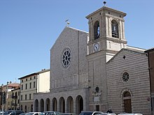
- Chiesa di San Michele Arcangelo , church in the center, contains the work Polittico di Sant'Angelo by Nicolò Alunno from 1499.
- Chiesa collegiata di Santa Croce , church in the center from 1295.
- Chiesa di San Rocco , church just outside the historic center. Contains two works by Dono Doni .
- Chiesa di San Paolo delle Abbadesse , Romanesque church with apse from the 11th century near the cemetery.
- Ponte sul Chiascio , historical bridge from 1548 over the Chiascio river at the confluence with the Tescio.
- Porta Sant'Angelo , city gate from the 13th century.
- Chiesa di San Giuseppe , church in the Costano district.
- Chiesa di San Francescuccio , also called San Francesco dei Mietitori , church in the Costano district.
- Santuario del SS. Crocifisso , sanctuary in the Costano district, was built in the 14th century.
- Chiesa parrocchiale di San Cristoforo , church in the district of Ospedalicchio, built in 1955.
- Rocca baglionesca , a fortress and from 1431 to the 16th century it was the seat of the Baglioni family.
Events
- Since 1962 the Palio de San Michele has been held in honor of the patron saint at the end of September , a palio in which the four districts (Rioni) of the historic center ( Moncioveta , Portella , San Rocco and Sant'Angelo ) take part.
Sons and daughters of the church
- Colomba Antonietti (1826-1849), patriot
- Marcello Bartolucci (* 1944), Archbishop of the Curia
- Pino Lancetti (1928–2007), fashion designer and designer
- Gualtiero Sigismondi (* 1961 in the Ospedalicchio district), Bishop of Orvieto-Todi
Community partnerships
- Höchberg , Germany , since 1990
- Karancslapujtő , small area Salgótarján , Hungary , since 2004
- Luz-Saint-Sauveur , Hautes-Pyrénées , France , since 1998
- Sant Sadurní d'Anoia , Spain
literature
- Touring Club Italiano : Umbria. Milan 1999, ISBN 88-365-2542-3 , p. 324.
Web links
- Official website of the municipality of Bastia Umbra
- Website of the Pro Loco in Bastia Umbra
Individual evidence
- ↑ Statistiche demografiche ISTAT. Monthly population statistics of the Istituto Nazionale di Statistica , as of December 31 of 2019.
- ↑ Website of the Agenzia nazionale per le nuove tecnologie, l'energia e lo sviluppo economico sostenibile (ENEA), accessed on May 18, 2014 (Italian) (PDF; 330 kB)
- ↑ a b c d Official website of the Istituto Nazionale di Statistica (2001), accessed on September 4, 2015 (Italian)
- ↑ a b c Touring Club Italiano


