
Chiascio
| Chiascio | ||
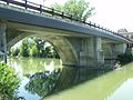
 The Chiascio at Bastia Umbra |
||
| Data | ||
| location | Perugia Province , Umbria , Italy | |
| River system | Tiber | |
| Drain over | Tiber → Tyrrhenian Sea | |
| River basin district | Appennino Centrale | |
| source | Monte Cucco near Gubbio | |
| Source height | 850 m | |
| muzzle | At Torgiano , Province of Perugia , in the Tiber Coordinates: 43 ° 1 ′ 6 " N , 12 ° 25 ′ 50" E 43 ° 1 ′ 6 " N , 12 ° 25 ′ 50" E
|
|
| length | 82 km | |
| Left tributaries | Rasina, Tescio , Topino | |
| Right tributaries | Saonda | |
| Medium-sized cities | Gubbio , Assisi | |
| Small towns | Bastia Umbra | |
| Communities | Valfabbrica , Bettona , Torgiano | |
The Chiascio [ ˈkjaʃo ] is a 82 km long river in Umbria , Italy .
course
The river, called Clasius by the Romans , arises on Monte Cucco southeast of Gubbio through the confluence of several small rivers. Then it turns southwest and passes the municipality of Valfabbrica , where the Saonda river joins from the right and the Rasina river from the left. Then he enters the municipality of Assisi and passes the Ponte a Petrignano , a bridge from the 14th century , in the district of Petrignano . The Chiascio now flows further south to Bastia Umbra , where on the northern edge of the historic center of the Tescio near the 1548 on the initiative of Pope Paul III. bridge Ponte sul Chiascio from the right. North of Passaggio (village of Bettona ) he joins the inflowing from left Topino and goes with him to 5 km just after the bridge Ponte a Rosciano (167 vertical meters) in the Parco dei Fiumi Chiascio e Tevere in Torgiano in the Tiber .
photos

Bridge Ponte a Petrignano in Petrignano, district of Assisi
Ponte a Rosciano bridge near Torgiano

Confluence of the Chiascio and Tiber rivers in the Parco dei Fiumi in Torgiano


literature
- Touring Club Italiano : Umbria , Milan 1999, pp. 257 ff., 323 f., ISBN 88-365-2542-3