Poggiodomo
| Poggiodomo | ||
|---|---|---|

|
|
|
| Country | Italy | |
| region | Umbria | |
| province | Perugia (PG) | |
| Coordinates | 42 ° 43 ' N , 12 ° 56' E | |
| height | 974 m slm | |
| surface | 40.01 km² | |
| Residents | 96 (Dec. 31, 2019) | |
| Population density | 2 inhabitants / km² | |
| Post Code | 06040 | |
| prefix | 0743 | |
| ISTAT number | 054042 | |
| Popular name | Pojani (also Poiani) | |
| Patron saint | Antonio abate (January 17th) | |
| Website | Poggiodomo parish | |
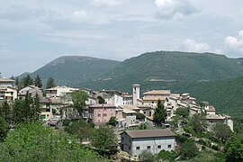
 Panorama of Poggiodomo |
||
Poggiodomo is an Italian commune with 96 inhabitants (as of December 31, 2019) in the province of Perugia in the Umbria region .
geography
The community extends over around 40 km² . This makes it the municipality with the lowest population density in Umbria. The municipality is located about 80 km southeast of Perugia on the Tissino river in the Neratal (Valnerina) on the mountains of Monte Carpenale and Monte Coscerno ( 1685 m slm ). It is part of the Comunità montana Valnerina and is part of the climatic classification of Italian communities in Zone E, 2910 GR / G.
The districts (Frazioni) include Mucciafora, Roccatamburo and Usigni. Mucciafora is 1070 meters above sea level and is the highest place in the Valneria valley. The district currently has about 44 inhabitants and is about 4 km from the main town. Usigni is 1001 meters above sea level, has around 13 inhabitants and has been part of the municipality of Poggiodomo since 1816.
The neighboring municipalities are Cascia , Cerreto di Spoleto , Monteleone di Spoleto , Norcia , Preci , Sant'Anatolia di Narco , Scheggino , Spoleto and Vallo di Nera .
history
The place arose in the 12th century around the castle built by the Counts of Spoleto. Already in 1361 the place no longer belonged to Spoleto, around 1377 it belonged to Cascia. At the beginning of the 16th century the place got into the conflicts between Cascia, Leonessa and Spoleto, in 1553 it finally fell under the power of Cascia. Poggiodomo was hit by a major earthquake in 1559 and 1703 . The place became an independent municipality in 1809 during the Napoleonic occupation , when the place was separated from Cascia. The place retained this status in the subsequent period in the Papal States . After the unification of Italy , the population increased from approx. 950 to over 1,350 inhabitants in 1900, after which the place experienced a population decline, which is currently around 150 inhabitants.
Attractions
- Chiesa di San Bartolomeo , church of Romanesque origin in the district of Mucciafora. The campanile dates from the 14th century.
- Chiesa di San Carlo Borromeo , church from 1635. It was built to replace the older Chiesa di Sant'Antonio da Padova .
- Chiesa di San Giovanni Battista , church from 1496.
- Chiesa di San Lorenzo , church from the 13th century with fresco cycle , also from the 13th century. Was changed significantly in 1566.
- Chiesa di San Nicola , church of Romanesque origin in the Roccatamburo district.
- Chiesa di San Pancrazio , 17th century church about 1 km outside the city walls.
- Chiesa di San Pietro , church, contains frescoes from the 15th and 16th centuries.
- Chiesa di San Salvadore , church in the district of Usigni, contains frescoes by an unknown artist from Cortona , created around 1644 on behalf of Cardinal Fausto Poli. The frescoes are by Salvo Castellucci Aretino , a student of Pietro da Cortona . The church was restored in 1927.
- Eremo della Madonna della Stella , Hermitage near the Roccatamburo district in Località Valle del Noce . Originated in the 12th century as a Benedictine monastery
- Palazzo Cardinale Fausto Poli , building from 1600 in the Usigni district.
Sons and daughters of the church
- Fausto Poli ( Cardinal Priest of San Crisogono from 1643 to 1653)
literature
- Touring Club Italiano : Umbria. Milan 1999, ISBN 88-365-2542-3 , p. 462
Web links
Individual evidence
- ↑ Statistiche demografiche ISTAT. Monthly population statistics of the Istituto Nazionale di Statistica , as of December 31 of 2019.
- ↑ La mia Umbria website, accessed May 5, 2011


