
Panicale
| Panicale | ||
|---|---|---|

|
|
|
| Country | Italy | |
| region | Umbria | |
| province | Perugia (PG) | |
| Coordinates | 43 ° 2 ' N , 12 ° 6' E | |
| height | 431 m slm | |
| surface | 78.84 km² | |
| Residents | 5,509 (Dec. 31, 2019) | |
| Population density | 70 inhabitants / km² | |
| Post Code | 06064, 06068 | |
| prefix | 075 | |
| ISTAT number | 054037 | |
| Popular name | Panicalesi | |
| Patron saint |
San Michele Arcangelo (September 29th) |
|
| Website | Panicale | |
 View of Panicale |
||

Panicale is an Italian commune with 5509 inhabitants (as of December 31, 2019) in the province of Perugia in the Umbria region and is a member of the association I borghi più belli d'Italia (The Most Beautiful Places in Italy).
geography
The municipality is located about 130 km southeast of Florence and about 30 km southwest of Perugia in a hilly area between Lake Trasimeno and the Nestore, a tributary of the Tiber . The place is part of the Comunità montana Trasimeno Medio Tevere .
The districts include Casalini, Cerreto, Colgiordano, Colle Calzolaro, Colle San Paolo, Gioveto, Lemura, Macereto, Migliaiolo, Mirabella, Missiano, Mongiovino, Montale, Poggio di Braccio, Tavernelle , Terrazzella and Via delle Parti.
Neighboring communities are Castiglione del Lago , Magione , Paciano , Perugia and Piegaro .
history
The first settlements in Panicale go back to 2000 BC. BC back. Then the Etruscans dominated the area, which was in close proximity to three cities of the Twelve Cities ( Arezzo , Chiusi and Perugia). In the Middle Ages, the place was strongly tied to Perugia and developed into its granary . In 1316 the first town charter was issued . The text was written in Latin by notary Pietro di Vannuccio and translated into Italian around 1484. From 1416 until his death in 1424 the place was under the rule of the Condottiere Braccio da Montone , who left the community to his successors. In 1540 Panicale and his protective power Perugia were taken by the Papal States and, with the exception of the French occupation from 1798 to 1813, remained under his rule until the Risorgimento .
Attractions
- Collegiata di San Michele Arcangelo , an 11th century church, enlarged in 1546 and restored in the 17th century. Contains the work Natività by Giovan Battista Caporali from 1519.
- Chiesa della Madonna della Sbarra , just outside the city walls, completed in 1625.
- Chiesa di San Sebastiano , contains the fresco Martirio di San Sebastiano by Perugino , created in 1505 .
- Chiesa di Sant'Agostino , completed in 1502. The altar was designed by Giambattista di Cristoforo in 1513.
- Chiesa di Santa Lucia , also Chiesa dell'Ospedale , church just outside the Porta Perugina in Via Pietro Vannucci.
- Chiesa di San Pietro e Paolo , church in the district of Colle San Paolo from 1143, which was built by the Benedictines.
- Santuario della Madonna di Mongiovino , contains a panel by Orazio Alfani

General plan
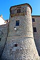
Part of the city fortifications

Collegiata di San Michele Arcangelo
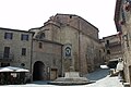
Back of the Collegiata in Piazza Umberto I

The church of Madonna della Sbarra

Santuario della Madonna di Mongiovino


Parish partnership
- La Verrière in the Yvelines department , France, since 1987.
Web links
Individual evidence
- ↑ Statistiche demografiche ISTAT. Monthly population statistics of the Istituto Nazionale di Statistica , as of December 31 of 2019.
- ^ I borghi più belli d'Italia. Borghipiubelliditalia.it, accessed August 13, 2017 (Italian).
- ^ I luoghi del silenzio: Colle San Paolo di Panicale (PG) , accessed on December 4, 2018 (Italian)

Assisi | Bastia Umbra | Bettona | Bevagna | Campello sul Clitunno | Cannara | Cascia | Castel Ritaldi | Castiglione del Lago | Cerreto di Spoleto | Citerna | Città della Pieve | Città di Castello | Collazzone | Corciano | Costacciaro | Deruta | Foligno | Fossato di Vico | Fratta Todina | Giano dell'Umbria | Gualdo Cattaneo | Gualdo Tadino | Gubbio | Lisciano Niccone | Magione | Marsciano | Massa Martana | Monte Castello di Vibio | Monte Santa Maria Tiberina | Montefalco | Monteleone di Spoleto | Montone | Nocera Umbra | Norcia | Paciano | Panicale | Passignano sul Trasimeno | Perugia | Piegaro | Pietralunga | Poggiodomo | Preci | San Giustino | Sant'Anatolia di Narco | Scheggia e Pascelupo | Scheggino | Sellano | Sigillo | Spello | Spoleto | Todi | Torgiano | Trevi | Tuoro sul Trasimeno | Umbertide | Valfabbrica | Vallo di Nera | Valtopina