
Paciano
| Paciano | ||
|---|---|---|

|
|
|
| Country | Italy | |
| region | Umbria | |
| province | Perugia (PG) | |
| Coordinates | 43 ° 1 ' N , 12 ° 4' E | |
| height | 391 m slm | |
| surface | 16.83 km² | |
| Residents | 968 (Dec. 31, 2019) | |
| Population density | 58 inhabitants / km² | |
| Post Code | 06060 | |
| prefix | 075 | |
| ISTAT number | 054036 | |
| Popular name | Pacianesi | |
| Patron saint | Santa Bonosa (August 13th) |
|
| Website | Paciano | |
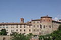
 View from the east |
||

Paciano is an Italian commune with 968 inhabitants (as of December 31, 2019) in the province of Perugia in the Umbria region and is a member of the association I borghi più belli d'Italia (The Most Beautiful Places in Italy).
geography
The municipality is located about 30 km southwest of Perugia on Monte Petrarvella. It is part of the communities Città dell'Olio , I borghi più belli d'Italia (The Most Beautiful Places in Italy) and the Comunità montana Trasimeno Medio Tevere and is in the climatic classification of Italian communities in Zone E, 2187 GR / G.
The neighboring municipalities are Castiglione del Lago , Città della Pieve , Panicale and Piegaro .
history
The castle Castello di Paciano was first mentioned in a document by Berengar I in 917 and was located in the oldest part of the village above today's municipality. The newer part of the place originated around the year 1300. It was called Castro Pacciani Novi and was under the rule of Chiusi . From the middle of the 13th century the place was ruled by Perugia. In 1313 the community was at war with Todi . In 1416 Paciano submitted to Braccio da Montone . After the Oddi family were expelled by the Baglioni in 1489, Perugia again took the place and fell under the control of the Papal States .
In 1643 Paciano was captured by Matteo de 'Medici , a son of Cosimo II. De' Medici , but shortly afterwards returned to the Papal States. In 1672, Pope Clement X. declared the place a county . In 1798 the place broke away from the Papal States for a year and joined the Roman Republic . By the Napoleonic occupation in 1809 Paciano was again separated from the Papal States. This separation lasted until 1816, when the town, this time independent of Panicale, was reassigned to the Papal States and remained there until the unification of Italy in 1860.
Attractions
- Chiesa di San Carlo Borromeo , a church that has existed since at least 1612 with a 17th century portal, restored in 1802.
- Chiesa di San Giuseppe from the 11th century, also called Chiesa dentro . Contains the flag image Madonna della Misericordia , also called Madonna delle Grazie , by Benedetto Bonfigli , created around 1480.
- Chiesa di San Salvatore del Ceraseto , outside the city walls.
- Chiesa di Santa Maria Assunta in cielo , just outside the city walls.
- Confraternita del SS. Sacramento with the Raccolta d'Arte di San Giuseppe art collection .
- Convento di Sant'Antonio , 1490 by the Franciscans founded the monastery just outside Paciano Vecchio, contained a picture of Paciano Master , which was spent in the National Gallery of Umbria in Perugia 1,872th
- Palazzo Cennini , building from the late 16th century.
- Santuario della Madonna della Stella , a sanctuary built between 1572 and 1579 just outside the city walls. Contains frescoes by Scilla Pecennini from the 16th century.
- City gates Porta Fiorentina and Porta Rastrella from the 13th century. The third city gate, Porta Perugina, is more recent.
- Torre d'Orlando , tower in the oldest part of the village.
City wall and clock tower
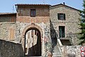
The city gate Porta Perugina
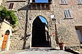
The city gate Porta Fiorentina

Chiesa di Santa Maria Assunta , near the Porta Fiorentina

Detail of the Chiesa di San Giuseppe church

The Santuario della Madonna della Stella


Community partnerships
- Fontaines , Yonne department, France, since 1996
- Mosman , Mosman Municipality, Australia, since 1998
literature
- TCI : Piccole città, Borghi e Villaggi , Vol. II, Milan 2007, pp. 258 f., ISBN 978-88-365-4145-4
- TCI: Umbria , Milan 1999, pp. 197 f., ISBN 88-365-2542-3
Web links
- Official website of the Municipality of Paciano (multilingual)
- umbriatourism.it: Paciano , pictures and interesting facts (German)
- Data and information on Paciano at Comuni Italiani (Italian)
Individual evidence
- ↑ Statistiche demografiche ISTAT. Monthly population statistics of the Istituto Nazionale di Statistica , as of December 31 of 2019.
- ^ I borghi più belli d'Italia. (official website), accessed August 13, 2017 (Italian).
- ↑ Città dell'Olio website , accessed on November 16, 2018
- ↑ Comunità Montana Trasimeno Medio Tevere website , accessed on May 9, 2011

Assisi | Bastia Umbra | Bettona | Bevagna | Campello sul Clitunno | Cannara | Cascia | Castel Ritaldi | Castiglione del Lago | Cerreto di Spoleto | Citerna | Città della Pieve | Città di Castello | Collazzone | Corciano | Costacciaro | Deruta | Foligno | Fossato di Vico | Fratta Todina | Giano dell'Umbria | Gualdo Cattaneo | Gualdo Tadino | Gubbio | Lisciano Niccone | Magione | Marsciano | Massa Martana | Monte Castello di Vibio | Monte Santa Maria Tiberina | Montefalco | Monteleone di Spoleto | Montone | Nocera Umbra | Norcia | Paciano | Panicale | Passignano sul Trasimeno | Perugia | Piegaro | Pietralunga | Poggiodomo | Preci | San Giustino | Sant'Anatolia di Narco | Scheggia e Pascelupo | Scheggino | Sellano | Sigillo | Spello | Spoleto | Todi | Torgiano | Trevi | Tuoro sul Trasimeno | Umbertide | Valfabbrica | Vallo di Nera | Valtopina