Pillertal
| Pillertal | ||
|---|---|---|
|
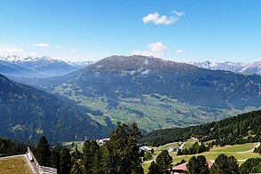
View from the mountain station of the Hochzeigerbahn to the Pillertal, behind it the Venet massif |
||
| location | Tyrol , Austria | |
| Waters | Pillerbach | |
| Mountains | Ötztal Alps | |
| Geographical location | 47 ° 8 '39 " N , 10 ° 42' 47" E | |
|
|
||
| length | 7 km | |
The Pillertal is about seven kilometers long, western side valley of the Pitztal , which branches off at Wenns . It is located in the Tyrolean Oberland of the state of Tyrol in Austria . The Pillerbach flows through the valley .
geography
Geographical location
The Pillertal branches off at an altitude of about 890 meters between Wenns and Jerzens , opposite the Hochzeiger , from the Pitztal and rises to the southwest to the Pillerhöhe , the 1559 meter high transition into the Oberinntal and Kaunertal . The Pillertal in the northwest is flanked by Venetmassiv and in the southeast rises High Aifner top as north pillar of the Kaunergrat to. While the deep valley areas in the northeast are used for agriculture as Wenner Schmalzkessel , the head of the valley in the southwest is densely forested.
Communities
The municipality of Wenns in the Imst district has a share in the lower Pillertal , and the municipality of Fließ in the Landeck district with the village of Piller comprises the upper Pillertal.

