Pinhão (Alijó)
| Pinhão | ||||||
|---|---|---|---|---|---|---|
|
||||||
| Basic data | ||||||
| Region : | Norte | |||||
| Sub-region : | Douro | |||||
| District : | Vila Real | |||||
| Concelho : | Alijó | |||||
| Coordinates : | 41 ° 11 ′ N , 7 ° 33 ′ W | |||||
| Residents: | 648 (as of June 30, 2011) | |||||
| Surface: | 3 km² (as of January 1, 2010) | |||||
| Population density : | 216 inhabitants per km² | |||||
| Postal code : | 5085-037 | |||||
| politics | ||||||
| Address of the municipal administration: | Junta de Freguesia de Pinhão Rua António Manuel Saraiva 5085-037 Pinhão |
|||||
| Website: | www.pinhao.com.sapo.pt | |||||
Pinhão is a place and a municipality ( freguesia ) in northern Portugal . It belongs to the district ( concelho ) of Alijó and has an area of 3 km² and 648 inhabitants (as of June 30, 2011).
history
Today's place was first mentioned in 1134 as a settlement in the municipality of São Pedro de Celeirós de Panóias . In 1933 Pinhão became an independent municipality, and in 1991 the place received the status of a vila (small town).
Culture and sights
The place is located at the mouth of the Rio Pinhão in the Douro in the center of the port wine growing region Alto Douro .
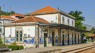
Pinhão is also known for its station on the Linha do Douro railway line, lined with numerous azulejos pictures . His architectural monuments also include the parish church Igreja Paroquial do Pinhão (also Capela de Nossa Senhora da Conceição ), which was only built in 1930 , with altarpieces made of polished wood and side panels with gilded wood carvings ( Talha dourada ).
Web links
- Map of the Freguesia Pinhão (Alijó) at the Instituto Geográfico do Exército
- Site site (port.)
Individual evidence
- ↑ www.ine.pt - indicator resident population by place of residence and sex; Decennial in the database of the Instituto Nacional de Estatística
- ↑ Overview of code assignments from Freguesias on epp.eurostat.ec.europa.eu
- ↑ www.monumentos.pt (under Cronologia ), accessed on February 4, 2013
- ↑ ditto


