Knot (Silvretta)
| node | ||
|---|---|---|
|
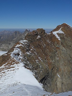
Knot from the southeast, from the connecting ridge to the Silvrettahorn , on the right the snow bell |
||
| height | 3190 m above sea level A. | |
| location | Vorarlberg , Austria / Graubünden , Switzerland | |
| Mountains | Silvretta | |
| Dominance | 0.18 km → snow bell | |
| Notch height | 15 m | |
| Coordinates , ( CH ) | 46 ° 51 '42 " N , 10 ° 5' 15" O ( 801 941 / 193 457 ) | |
|
|
||
The knot or Piz Grambola ( 3190 m above sea level ) is a summit in the Silvretta on the border between the Austrian state of Vorarlberg and the Swiss canton of Graubünden .
Location and surroundings
The knot is the intersection of three ridges. To the south-east it is connected to the Silvrettahorn ( 3244 m ) via the Silvrettalücke ( 3140 m ) , to the west via the Rotfluhlücke ( 3070 m ) with the Rotfluh ( 3166 m ), both neighboring peaks are about 500 meters away. In the north there is the snow bell ( 3223 m ) only about 400 meters away , the connecting ridge is only about 15 meters deep , which is why the knot is not a particularly independent summit. However, it represents a prominent point in the Silvretta ridge, which represents the state border , because it turns here from the west, coming from the Rote Furka , first to the southeast and south.
The knot forms the apex of three glacier basins: the Silvretta Glacier is located in the southwest , the Klostertal Glacier in the northwest and the Snow Bell Glacier in the east. At the latter, the knot breaks off with a 250 meter high wall.
Alpinism
Most of the time, the knot is "taken along" when climbing the snow bell and is exceeded in the process. This is possible on the one hand as part of an ascent of the entire ridge from the Silvrettahorn to the snow bell, whereby the Silvrettahorn can be reached from the Wiesbadener Hütte over the Ochsentaler glacier or over the Silvretta glacier and further over the south ridge. On the other hand, the junction can also be reached from the Klostertal from the west via the Klostertal glacier or from the south via the Rotfluhlücke. Both variants are also common as a ski tour.
Literature and map
- Günther Flaig, Walther Flaig: Silvretta alpin. Bergverlag Rother, Munich 1996, ISBN 3-7633-1097-5 .
- Alpine Club map sheet 26, 1: 25,000: Silvretta group. ISBN 3-928777-35-1 .
Individual evidence
- ↑ a b c Günther Flaig, Walther Flaig: Silvretta alpin. Bergverlag Rother, Munich 1996, ISBN 3-7633-1097-5 , p. 185
- ↑ Alpine Club Map, sheet 26, 1: 25,000: Silvrettagruppe. ISBN 3-928777-35-1
- ↑ Silvrettahorn 3244m and Snow Bell 3223m. Crossing and descent into the Klostertal to the Madlenerhaus. Tour description, published by Wiesbadener Hütte
- ↑ Silvrettahorn 3244m with the summit possibility Egghorn 3147m, or the crossing to the snow bell 3223m, and descent into the Klostertal to the Madlenerhaus. Tour description, published by Wiesbadener Hütte

