
Plästerlegge
.JPG)

The Plästerlegge is the highest natural waterfall in the Sauerland and North Rhine-Westphalia . It is located east of the Bestwig district of Wasserfall in the northern Rothaar Mountains , which are part of the Rhenish Slate Mountains . The steep valley basin with the waterfall is part of the 13.7 hectare nature reserve Plästerlegge - Auf'm Kipp . The name Plästerlegge is a dialect of the Sauerland plateau and means something like "raining slate rock", composed of the terms blästern ("pattering, raining like a cloudburst") and Legge ("schiefriger Fels").
The waterfall can fall dry after longer periods of dry weather. The water falls to gefällearmem upper reaches of around 700 m length first well 20 m almost vertically over a ledge in the shale rock in a slightly stepped ravine-like basin and flows then about 500 m as a torrent through a debris body as a residue of a debris glacier from the Weichselkaltzeit interpreted can be. The water flows to the Elpe , which belongs to the river system of the Ruhr , and thus the Rhine .
At the southern edge of the waterfall there is a tower-like structure. Behind this parapet formerly was lead ore melted from adjacent mines. The liquid lead was poured into the waterfall. When falling in the waterfall, small lead balls formed, which cooled immediately. Such lead balls can still be found at the foot of the waterfall.

New nature protection shield
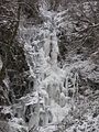
Frozen waterfall (December 2009)

Plästerlegge in thaw (March 2013)

Plästerlegge with little water (April 2011)

Impact zone of the Plästerlegge
Debris slopes below the fall and walls

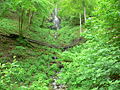
Torrent below the Plästerlegge
.JPG)


_2.JPG)
literature
- Siegfried Haas: The Plästerlegge - a natural spectacle. Yearbook Hochsauerlandkreis 1999. Podzun-Verlag, Brilon 1999.
- Hochsauerlandkreis - Lower Landscape Authority: Landscape Plan Bestwig , Meschede 2008, p. 31 (PDF; 915 kB)
See also
Web links
Individual evidence
- ↑ cf. Michael Kaub: Sauerland Travel Guide , p. 107, Westflügel Verlag, 2009, ISBN 978-3-939408-06-2
- ^ Karl N. Thomé: Waterfall and rubble glacier southeast of Ramsbeck in: Geologische Karte 1: 100,000 C4714, explanations, Arnsberg 1981, pp. 55–57
Coordinates: 51 ° 18 ′ 3 ″ N , 8 ° 26 ′ 18 ″ E