Waterfall (Bestwig)
|
waterfall
Bestwig municipality
Coordinates: 51 ° 18 ′ 4 ″ N , 8 ° 26 ′ 0 ″ E
|
|
|---|---|
| Height : | 618 m |
| Residents : | 73 (Jun 30, 2012) |
| Postal code : | 59909 |
| Primaries : | 02905, # |
|
Waterfall from the air
|
|
Waterfall is part of the municipality of Bestwig ( Hochsauerlandkreis ). On June 30, 2012, Wasserfall had 73 residents. The place is at an altitude of 600 m and is one of the highest places in the region.
history
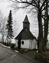
The village was first mentioned in a document in 1560. The first inhabitants were probably charcoal burners, shepherds and farmers. The area where the village stands today belonged to Wiggeringhausen. It is believed that the first residents produced charcoal for the ironworks in Wiggeringhausen. The farmers have made the area arable. In 1583, the waterfall of Wiggeringhausen was replaced. In 1649 it is mentioned that practically all usable wood was converted into coal. The residents had to survive on their very low income as day laborers. The St. Antonius Chapel was built around 1710. In 1816 the harvest was canceled due to bad weather conditions. The residents got rye from the area around Gdansk.
In July 2010 the place celebrated its 450th anniversary and at the same time the 300th anniversary of the local St. Antonius Chapel.
tourism
Tourism is of great importance. In Wasserfall there are winter sports (ski lift) and two campsites. About 500 m north are the well-known amusement park Fort Fun Adventure Land and the panoramic mountain Stüppel with restaurant and lift. The Plästerlegge , the highest natural waterfall in North Rhine-Westphalia, is located in the nature reserve Plästerlegge - Auf'm Kipp east of the waterfall town.
Web links
- Waterfall ( Memento from October 28, 2010 in the Internet Archive )
- Entry on sauerland-waldroute.de
Individual evidence
- ↑ Municipality of Bestwig: Brochure information of the municipality of Bestwig , edition 2012, page 37.

