Podvrší (mountain)
| Podvrší | ||
|---|---|---|
|
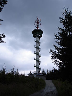
Lookout tower on Podvrší |
||
| height | 590 m nm | |
| location | Czech Republic | |
| Mountains | Drahanská vrchovina | |
| Coordinates | 49 ° 23 '21 " N , 16 ° 42' 15" E | |
|
|
||
| Type | Ridges | |
The Podvrší (590 m) is a mountain in Drahanská highlands in the Czech Republic .
Location and surroundings
Podvrší is located five kilometers northeast of Blansko in Drahanská vrchovina. The Veselice district of the Vavřinec municipality is located directly on the shoulder of the mountain . Immediately to the east of the mountain extends the landscape of the Moravian Karst, characterized by deep valleys, caves and sinkholes .
history
Because of its exposed location, the mountain was designated in the 1990s by the Czech mobile operator Eurotel as the location of a transmitter for radio link connections. In 2001, a 31-meter-high concrete tower with an antenna system and a viewing platform for the public was built on Podvrší. After three months of construction, the exceptionally slim tower was completed on July 26, 2001.
view
From the tower there is a very comprehensive panoramic view of the hills north of Brno . In the south, the cooling towers of the Dukovany nuclear power plant can be seen on a clear day.
Paths to the summit
- Podvrší is located on a blue- marked hiking trail that starts in Blansko and continues towards Sloup in the Moravian Karst. A fork leads to the summit.
- The village of Veselice is also a good starting point for a visit to Podvrší. About the above Hiking route, the summit of the mountain can be reached in about 10 minutes.

