Point Reyes Lighthouse
| Point Reyes Lighthouse | ||
|---|---|---|
| National Register of Historic Places | ||
| Historic District | ||
|
Point Reyes lighthouse after a major renovation in 2019 |
||
|
|
||
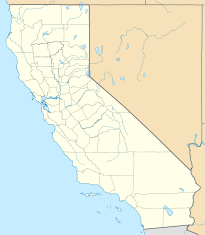
| location | Point Reyes , Marin County , California | |
| Coordinates | 37 ° 59 '44.9 " N , 123 ° 1' 23" W | |
| Built | 1870 | |
| NRHP number | 91001100 | |
| The NRHP added | 3rd September 1991 | |
The Point Reyes Lighthouse , also known as Point Reyes Light or Point Reyes Light Station is known, a lighthouse at the California Pacific coast in the Peninsula Point Reyes in Marin County northwest of San Francisco . It is listed as a historic structure on the National Register of Historic Places and was a key location in the film The Fog .
Location and design
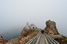
The location of Point Reyes Lighthouse in the National Seashore is the windiest location on the North American Pacific coast and has the second highest probability of fog occurrence in North America after Nantucket . In particularly heavy fog, visibility can drop to a little more than three meters. Especially in summer, the fog can last for weeks and hide the rocky cape. For ships sailing into or out of San Francisco Bay , the cape , which protrudes 15 kilometers into the Pacific, represents a particularly dangerous moment. After 60 ship sinks near Point Reyes, it was decided in 1855 to build a lighthouse on the cape.
The lighthouse at the far western end of the triangular peninsula was designed for a workforce of four. Point Reyes Lighthouse features a 16-sided structure made of forged iron plates that is bolted to the rock below. This design is identical to that of the lighthouse at Cape Mendocino , which was put into operation in 1869. The beacon is eleven meters high, while the focal plane is 88 m above sea level . Point Reyes Lighthouse also had a foghorn . The accommodations for the workforce, usually the lighthouse keeper and three workers, were located on the rocky plateau around 800 meters away. 304 steps led down to Point Reyes Lighthouse. The building for the Nebelhorn was 50 meters below the lighthouse, and another 338 steps led down to it. In 1934 the Nebelhorn was moved to a small building right next to the lighthouse.
The weather conditions at Point Reyes are extreme. Winds are usually 60 km / h and there are more than 2100 hours of fog per year. The logbooks report that the fog once lasted 176 hours - over a week - and during that time 24,500 pounds of coal were required to keep the foghorn operating.
history
As early as 1855 the construction of a lighthouse in Point Reyes had been decided. The construction was delayed by years because for a long time no agreement could be reached with the landowners on the purchase price of the site. During this time alone, 14 ships sank near the Cape. The 2700 kilogram Fresnel lens and the mechanical components for the lighthouse were manufactured in France in 1867 by Barbier and Fenestre . The building materials were delivered to Drakes Bay by ship . The further transport to the 180 meter high rock plateau was carried out with ox carts . In order to set up the lighthouse below the high fog zone, a building site was leveled 90 meters below the Kaphöhe using dynamite blasting. This had not been taken into account with the Point Bonita lighthouse, which had previously been built in the nearby Marin Headlands , which is why it had to be relocated to a lower location after a few years. This relocation also changed the original plan. Instead of a two-storey residential building with an integrated tower on Kaphöhe, as realized at the same time at Old Point Loma and Point Pinos Lighthouse , the lighthouse was now anchored separately from the residential buildings at an exposed location in the rock. Point Reyes Lighthouse entered service on December 1, 1870. In operation, the lens rotated every two minutes so that a ship saw the light signal flash every five seconds.
Despite the lighthouse, more wrecks accumulated on the coast of Point Reyes in the years that followed. In 1890 a sea rescue station was built north of the lighthouse. This was replaced in 1927 by the Point Reyes Lifeboat Station , 4.5 kilometers east . It was in operation until 1968 and is now a National Historic Landmark . In 1901, the National Weather Service built a weather station at the start of the stairs to the lighthouse due to the exceptional weather conditions and storm warnings .
In the 1906 San Francisco earthquake , the peninsula was moved more than five meters north within a minute without the lighthouse being damaged. Only the Fresnel lens was lifted out of its frame. After a thirteen-minute repair, the beacon was functional again.
The electrification of Point Reyes Lighthouse took place in 1938. A year later, the stairs were on the basis of concrete modernized. Point Reyes Lighthouse was converted to unmanned operation on June 12, 1975 by the United States Coast Guard . The building fabric with the Fresnel lens was transferred to the National Park Service and replaced by an automated electronic lighting system, which is located just a few meters below the lighthouse in a small wooden building. A museum was opened in the lighthouse on August 15, 1977, which focuses on the life of the lighthouse keepers. In 1980 Point Reyes Lighthouse played an important role as a location in the film The Fog . There Adrienne Barbeau played the radio presenter Stevie Wayne, who uses the lighthouse as a broadcasting station and receives unpleasant visits from vengeful ghosts of drowned sailors. In the film, the location is called Spivey Point and overlooks the village of Antonio Bay.
On September 3, 1991, the lighthouse was added to the National Register of Historic Places as a Historic District . In 2003, Point Reyes Lighthouse and stairs were undergoing major renovations . Despite its remoteness, the lighthouse is a popular tourist attraction in Marin County and is visited by hundreds of people every day. Gray whales can be observed from there in November and spring .
Point Reyes Lighthouse Visitor Center
A visitor center is located above the beacon . It shows the history of the beacon and, since summer 2016, an exhibition on the marine ecosystems of the California coast.
Web links
- Photo collection on the National Register of Historic Places. In: National Register of Historic Places database. National Park Service , January 4, 2008, accessed September 4, 2011 (PDF 458 KB).
- Tony Reeves: The Fog (1979) film locations. In: web presence movie-locations.com. The Worldwide Guide to Movie Locations, accessed March 1, 2013 .
Individual evidence
- ↑ a b c Jessica Location: Point Reyes . The Complete Guide To The National Sehashore & Surrounding Area. Wilderness Press, Berkeley 2004, ISBN 0-89997-350-7 , pp. 163 (English, Google Books [accessed March 6, 2013]).
- ^ Kathleen Goodwin, Point Reyes Visions . 2nd Edition. Color & Light Editions, Singapore 2005, ISBN 0-9671527-4-7 , pp. 77 (English, Google Books [accessed March 6, 2013]).
- ↑ a b c d e f g h i Point Reyes, CA. In: website Lighthousefriends.com. Lighthouse Friends, accessed March 1, 2013 .
- ↑ Unless otherwise stated, the information is based on Point Reyes. Lighthouse History at Point Reyes. In: website nps.gov. National Park Service , accessed February 28, 2013 .
- ^ California. Historic Light Station Information & Photography. In: US Coast Guard History Program . United States Coast Guard , accessed February 28, 2013 .
- ^ Point Reyes Light Station on the National Register Information System. National Park Service , accessed July 15, 2017
- ↑ Jessica Location: Point Reyes . The Complete Guide To The National Sehashore & Surrounding Area. Wilderness Press, Berkeley 2004, ISBN 0-89997-350-7 , pp. 162 (English, Google Books [accessed March 6, 2013]).
- ↑ National Parks Traveler: Ocean Exploration Center Opens At Point Reyes National Seashore , June 8, 2016


