
Ponte do Freixo
Coordinates: 41 ° 8 ′ 30 " N , 8 ° 34 ′ 51" W.
| Ponte do Freixo | ||
|---|---|---|
.jpg) |
||
| use | Highway bridge | |
| Crossing of | Douro | |
| place | Porto - Vila Nova de Gaia | |
| construction | haunched girder bridge | |
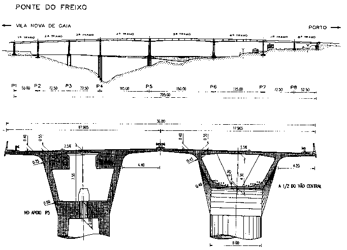
| overall length | 750 m | |
| width | 36 m | |
| Number of openings | eight | |
| Longest span | 150 m | |
| completion | 1995 | |
| planner | António Reis | |
| location | ||
|
||

The Ponte do Freixo is an eight-lane motorway bridge over the Douro between Porto and Vila Nova de Gaia , which leads the Autoestrada A20 and at the same time the IC23 - Via de Cintura Interna over the river, a 21 km long expressway around the centers of the two cities, which began with the Ponte da Arrábida in 1963 on the other side of Porto.
It is named after the neighboring district of Porto.
It stands 1.3 km above the Ponte de São João and is the last bridge upstream over the Douro in Porto. The next river crossing upstream is the Crestuma-Lever power station, 15 km away, and the bridge of the A41 , the regional ring road of Porto ( CREP-Circular Regional Exterior do Porto ), another 3 km away .
It was built from 1993 to 1995 according to plans by António Reis .
The Ponte do Freixo is 750 meters long and 36 wide; on the south side there is a distribution structure. It has 8 openings with one opening of 150 m and two openings of 115 m. The bridge consists of two parallel bridges 10 cm apart with four lanes each in one direction of travel. Each of the bridges consists of a haunched , single-cell prestressed concrete - hollow box with a cantilevered deck.
Web links
- Ponte do Freixo. In: Structurae
- Ponte Do Freixo on the website of the Centro Histórico do Porto
- Ponte Do Freixo on the Soares da Costa website
Individual evidence
- ^ Ponte do Freixo elevation and cross-section