
Porsuk
| Porsuk | ||||
|
||||
 Mosque in Porsuk |
||||
| Basic data | ||||
|---|---|---|---|---|
| Province (il) : | Niğde | |||
| District ( ilçe ) : | Ulukışla | |||
| Coordinates : | 37 ° 30 ' N , 34 ° 35' E | |||
| Height : | 1324 m | |||
| Residents : | 360 (2015) | |||
| Telephone code : | (+90) 388 | |||
| Postal code : | 51900 | |||
| License plate : | 51 | |||
| Structure and administration (as of 2016) | ||||
| Mayor : | Faruk Unver | |||


Porsuk is a village in the county Ulukisla the Turkish province of Nigde . Today the village is located south of the D-750 highway between Ulukışla in the west and Pozantı in the east. The distance to Ulukışla is about 10 kilometers, the provincial capital Niğde is about 50 kilometers north. The place is located in the northern foothills of the Bolkar Dağları Mountains . The former village north of the road, today Eski Porsuk (Old Porsuk), has fallen into disrepair.
About one kilometer northeast of the village is the Hittite settlement hill Porsuk Hüyük . The late Hittite inscription from Porsuk was found there in 1960 and is now exhibited in the Niğde Archaeological Museum .

Eski Porsuk
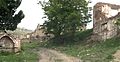
Eski Porsuk


Web links
Individual evidence
- ^ Website of the district , accessed March 10, 2016