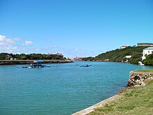
Port Alfred
| Port Alfred | ||
|---|---|---|
|
|
||
| Coordinates | 33 ° 36 ′ S , 26 ° 54 ′ E | |
| Basic data | ||
| Country | South Africa | |
| Eastern Cape | ||
| District | Sarah Baartman | |
| ISO 3166-2 | ZA-EC | |
| local community | Ndlambe | |
| Residents | 6287 (2001) | |
| founding | 1820 | |
| Website | www.portalfred.co.za (English) | |
|
Bridge in Port Alfred
|
||
Port Alfred is a town in Ndlambe municipality , Sarah Baartman district , Eastern Cape Province in South Africa . It is halfway between Port Elizabeth and East London (both 150 kilometers away) at the mouth of the Kowie River. The river divides the city in half. The city is also the seat of the local government. In 2001 it had 6,287 inhabitants.
history
The city was founded around 1820 by British settlers who were settled by Lord Charles Henry Somerset as a buffer to the Xhosa in the east of the Cape Colony . The city was originally named Port Kowie, after the river on which it lies. Then the name was changed to Port Frances, after the daughter-in-law of the governor Lord Somerset . In 1860 the name was changed to Port Alfred after Prince Alfred , the second son of Queen Victoria , who was visiting South Africa at the time.
Attractions
Due to the wide sandy beaches and the numerous artificial islands in the mouth of the Kowie River - where the large marina is located - the city is now a holiday destination for water sports enthusiasts.
The artificial islands in the estuary are called marinas. As a gated community, they are privately owned and not open to the public. However, the canals in between are accessible by boat or canoe.
The 1827 Methodist Settlers' Church is a national monument.
sons and daughters of the town
- Yolandi Visser (* 1984), musician
Web links
- Official site of the City (English)
Individual evidence
- ↑ 2001 Census , accessed April 30, 2013
- ↑ Port Alfred (at go2africa)
- ↑ Port Alfred ( Memento from September 3, 2011 in the Internet Archive ) at africantravelexperiences.com (English)


