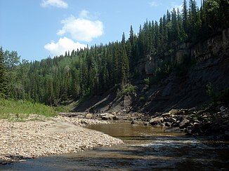
Pouce Coupe River
| Pouce Coupe River | ||
|
Pouce Coupe River Canyon after confluence with Saskatoon Creek |
||
| Data | ||
| location | Alberta , British Columbia (Canada) | |
| River system | Mackenzie River | |
| Drain over | Peace River → Slave River → Mackenzie River → Arctic Ocean | |
| source | in Saddle Hills County , Alberta, 55 ° 40 ′ 58 ″ N , 119 ° 13 ′ 32 ″ W |
|
| Source height | approx. 860 m | |
| muzzle |
Peace River Coordinates: 56 ° 7 '54 " N , 119 ° 54' 39" W 56 ° 7 '54 " N , 119 ° 54' 39" W. |
|
| Mouth height | 412 m | |
| Height difference | approx. 448 m | |
| Bottom slope | approx. 3 ‰ | |
| length | approx. 150 km | |
| Discharge at gauge below Henderson Creek A Eo : 2850 km² |
MQ 1971/2000 Mq 1971/2000 |
7 m³ / s 2.5 l / (s km²) |
| Left tributaries | Tupper Creek , Dawson Creek , Saskatoon Creek | |
| Right tributaries | Henderson Creek | |
| Communities | Pouce Coupe | |
|
Landry Road Bridge over the Pouce Coupe River |
||
The Pouce Coupé River is a right tributary of the Peace River in the Canadian provinces of Alberta and British Columbia .
The Pouce Coupé River has its source in Saddle Hills County , Alberta. It initially flows in a westerly direction, crosses the provincial border into British Columbia and turns north there. It passes the town of Pouce Coupe , takes the river of the same name from the left 5 km east of Dawson Creek , is crossed by British Columbia Highway 49 and flows in a north-northeast direction back to Alberta. About 5 km east of the provincial border, the Pouce Coupé River flows into the Peace River. The Pouce Coupé River has a length of about 150 km.
Web links
- Pouce Coupe River . In: BC Geographical Names (English)
Individual evidence
- ↑ Pouce Coupé River at the gauge below Henderson Creek - hydrographic data from R-ArcticNET

