Prince of Wales Island (Nunavut)
| Prince of Wales Island / Prince of Wales Island / Kinngailaq | |
|---|---|
| Satellite photomontage of the Prince of Wales Island | |
| Waters | Arctic Ocean |
| Geographical location | 72 ° 36 ′ N , 98 ° 32 ′ W |
| surface | 33,339 km² |
| Highest elevation | (unnamed) 320 m |
| Residents | uninhabited |
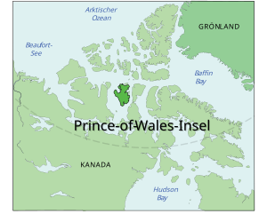
| Map of the island | |
The Prince of Wales Island (or Prince of Wales Island , Engl. Prince of Wales Iceland , Inuktitut Kinngailaq ) is an island in the Canadian Arctic Archipelago- . Administratively, it belongs to the Nunavut Territory . It was first explored in 1851 by William Kennedy and Joseph-René Bellot while searching for John Franklin's missing Arctic expedition . The island is named after Albert Edward, the eldest son of Queen Victoria , the ten-year-old Prince of Wales. The later King Edward VII.
geography
The island south of the Queen Elizabeth Islands lies between Victoria Island in the west and Somerset Island in the east. With an area of 33,339 km² it ranks 10th among the largest islands in Canada and 40th among the largest islands in the world , but has no permanent settlement. Its surface is shaped by tundra .
Web links
- Prince of Wales Island ( English, French ) In: The Canadian Encyclopedia .
Individual evidence
- ↑ Darren Keith: Inuit Qaujimaningit Nanurnut Inuit Knowledge of Polar Bears (PDF; 7.0 MB). Gjoa Haven Hunters 'and Trappers' Organization and CCI Press, 2005, Appendix 5.
- ↑ The Atlas of Canada - Sea Islands ( Memento from October 6, 2012 in the Internet Archive )


