
Puente San Marcos
Coordinates: 20 ° 20 ′ 35 " N , 97 ° 57 ′ 41" W.
| Puente San Marcos | ||
|---|---|---|
 |
||
| Official name | Puente Ingeniero Gilberto Borja Navarrete | |
| Convicted |
|
|
| Crossing of | Río San Marcos | |
| place | at Xicotepec de Juárez | |
| construction | Prestressed concrete - girder bridge | |
| overall length | 850 m | |
| width | 18.70 m | |
| Number of openings | seven | |
| Longest span | 180 m | |
| start of building | 2009 | |
| completion | 2013 | |
| planner | FCC | |
| location | ||
|
||
 |
||

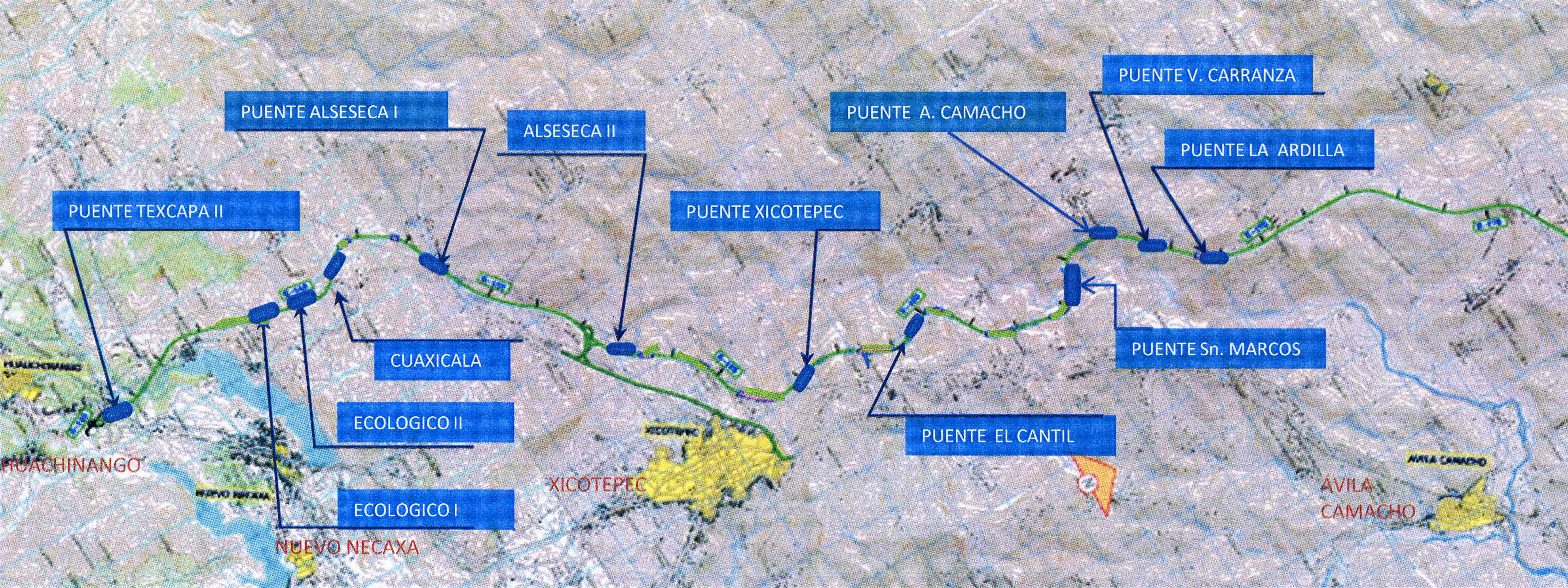
The Puente San Marcos (officially Puente Ingeniero Gilberto Borja Navarrete ) is a four-lane road bridge on the Mexican Carretera Federal 132D on the route from Mexico City to Tuxpan on the Gulf of Mexico . In the Nuevo Necaxa - Tihuatlán section, completed in 2014 , it crosses the Río San Marcos near the town of Xicotepec de Juárez in the state of Puebla .
The 37 km long section Nuevo Necaxa - Ávila Camacho was the most demanding part of Carretera Federal 132D with 6 tunnels and 9 bridges.
description
The Puente San Marcos is the largest and longest of these bridges with a length of 850 m and a height of 226 m above the Río San Marcos. In the ground plan it describes a curve with a constant radius of 1150 m and has a gradient of 5.8%. It has 7 openings with spans of 57 + 98 + 3 × 180 + 98 + 57 m.
The prestressed concrete - girder bridge has a 18,70 m wide carriageway panel and a unicellular, 9.2 m wide hollow box , whose overall height of 10.0 m on the pillars decreases up to 3.6 m in center field.
The pillar no. 4 with a height of 208 m above the 7.5 m high foundations of bridge piers second highest in the world (after 245 m high pillar no. 2 of the Millau Viaduct ). The other piers are 33 m (P1), 76 m (P2), 166 m (P3), 121 m (P5) and 54 m (P6) high. The pillars have a rectangular hollow cross-section of 9.2 × 8.0 m at the head, which increases slightly towards the bottom. Pillar No. 4 has a cross-section of 17.53 × 13.55 m at the base. Its reinforced concrete foundation in the shape of a truncated pyramid is anchored up to 25 m deep in the ground with 73 bored piles. The pillars were erected with conventional climbing formwork; for Pillar No. 4, PERI self-climbing formwork was used.
During the planning phase, extensive wind tunnel tests were carried out on the bridge and the shape of the valley. This shows that New Jersey concrete barriers as the outer lane delimitation offer adequate protection for the trucks from gusts of wind.
The bridge was planned by the Spanish company FCC Construcción , the execution by a joint venture between FCC Construcción and the Mexican ICA (Ingenieros Civiles Asociados).
Construction of the bridge began in 2009 and was completed in 2012. The section of the road was opened to traffic in 2014 after other work.
Web links
- San Marcos Bridge on HighestBridges.com
- David Arribas Mazarracína, José Ignacio González Esteban, José María Pérez Casas, Pablo Bernal Sahún: Viaducto Gilberto Borja Navarrete. In: Hormigón y Acero , January – April 2015; Volume 66, Issue 275, pp. 1–21 (Spanish) (PDF; 2.2 KB)
Individual evidence
- ↑ Puente Texcapa II, Puente Alseseca I, Puente Alseseca II, Puente Xicotepec, Puente El Catil, Puente San Marcos, Puente A. Camacho, Puente V. Carranza, Puente Ardilla; see. Tuxpan highway bridge map on HighestBridges.com
- ↑ The following information is based on: David Arribas Mazarracína, José Ignacio González Esteban, José María Pérez Casas, Pablo Bernal Sahún: Viaducto Gilberto Borja Navarrete. In: Hormigón y Acero 2015; 66 (275): 1–21 (Spanish) (PDF; 2.2 KB)