Puerto Rico Trench

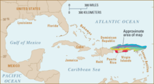
The Puerto Rico Trench is a deep sea channel up to 9219 m (according to other data up to 8380 m) and 800 km long deep-sea channel in the west of the Atlantic Ocean , which contains the deepest point in the Atlantic.
geography
The Puerto Rico Trench is located directly north of the junction of the Greater and Lesser Antilles on the southwestern edge of the North Atlantic . It is located between the North American pool in the Sargasso Sea in the northwest, north and northeast, the Guyanabecken the east and southeast and to the Leeward Islands belonging Leeward Islands in the southeast, Puerto Rico in the south and the Dominican Republic in the southwest and west.
geology
The Puerto Rico Trench forms the northern part of the deeply incised seam of the North American Plate in the north and the Caribbean Plate in the south.
exploration
The deep sea channel has already been the target of scientific studies on several occasions because it can be reached quickly due to its proximity to the mainland. Initially, the water depth was measured with deep levels. During the Challenger expedition on March 26, 1876, a depth of 3875 fathoms (7087 m) was measured. On January 27, 1883, a sounding aboard the oceanographic research vessel USC & GS George S. Blake determined a depth of 4561 fathoms (8341 m) and this point was named Brownson Deep after Willard H. Brownson .
The first echo sounders were carried out on board the USS Milwaukee . On February 14, 1939, a depth of 4780 fathoms (8741 m) was measured with an NM-9 echo sounder and after applying a correction table the value was 5041 fathoms (9219 m). This place has been called Milwaukeetief ever since . A 1955 survey of the deep sea channel by Maurice Ewing and Bruce C. Heezen by means of an echo sounder indicated that the bottom was flat at a depth of 8,380 m.
In order to test theories about the formation of this deep sea channel, the structure of the lithosphere in the area of the Puerto Rico Trench was investigated by means of seismic refraction studies in 1954 and 1959. It was found that the Mohorovičić discontinuity is located at depths between 9 and 12 km below the sea surface.
In 1964, dives were carried out for the first time as part of Operation Deepscan in American-French cooperation. The French Navy supported the project with the deep-sea submersible Archimède and its mother ship Marcel Le Bihan . On the American side, the research vessel USNS Robert D. Conrad of the Lamont-Doherty Earth Observatory and the research vessel Atlantis II of the Oceanographic Institute in Woods Hole were in use. During twelve dives u. a. Rock samples taken.
On December 19, 2018, the Texan Victor Vescovo reached the bottom of the deep-sea channel with his deep-sea submersible Limiting Factor during a six-hour dive at 8,376 m.
See also
Web links
- Alan J. Jamieson, Heather A. Stewart, Paul – Henri Nargeolet: Exploration of the Puerto Rico Trench in the mid-twentieth century: Today's significance and relevance In: Endeavor , Volume, No. und, 2020, ISSN 0160-9327 , p . ( https://doi.org/10.1016/j.endeavour.2020.100719 ).
- Alan Jamieson, Thomas Linley, Heather Stewart, Paul-Henri Nargeolet, Victor Vescovo: Revisiting the 1964 Archimède bathyscaphe dive to 7300 m in the Puerto Rico trench, abundance of an elasipodid holothurian Peniagone sp. and a resolution to the identity of the 'Puerto Rican snailfish' In: Oceanographic Research Papers , Deep Sea Research Part I, No. 103336, 2020, ISSN 0967-0637 , S., ( https://doi.org/10.1016/ j.dsr.2020.103336 ).
Individual evidence
- ^ J. Lyman: The Deepest Sounding in the North Atlantic . Proceedings of the Royal Society of London. Series A, Mathematical and Physical Sciences Volume 222, No. 1150, March 18, 1954, available online at page 334 of the article at pages 334-336
- ↑ Kenneth O. Emery, Elazar Uchupi: The Geology of the Atlantic Ocean . Springer Verlag New York Inc., 1984, ISBN 978-0-387-96032-6 , pp. 161-163, Google Book Scan of the relevant pages, pp. 161-163
- ^ J. Northrop, M. Ransone: Some Seismic Profiles near the Western End of the Puerto Rico Trench. In: The Journal of general physiology. Volume 45, number 4, March 1962, pp. 243-251, doi : 10.1085 / jgp.45.4.243 , PMID 19873544 , PMC 2195213 (free full text).
- ^ Wallace Cloud: Jeeps in the Deepː Exploring Innerspace at 4,500 Fathoms . Popular Science, August 1964, Google Books scan of the article on Archiméde Tauchgang pp. 42–46 and p. 180, accessed January 20, 2019
- ↑ Online article from US magazine Popular Science about diving in the Puerto Rico Trench , accessed January 20, 2019.


