Pukepoto
| Pukepoto | ||
| Geographical location | ||
|
|
||
| Coordinates | 35 ° 10 ′ S , 173 ° 13 ′ E | |
| Region ISO | NZ-NTL | |
| Country |
|
|
| region | Northland | |
| District | Far North District | |
| Ward | Te Hiku Ward | |
| Residents | few | |
| height | 33 m | |
| Post Code | 0481 | |
| Telephone code | +64 (0) 9 | |
| Photography of the place | ||
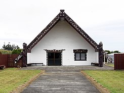
 Te Uri O Hina Marae in Pukepoto |
||
Pukepoto is a settlement in the Far North District of Northland on the North Island of New Zealand .
geography
The settlement is located around 6 km southwest of Kaitaia and around 6 km east of Ahipara , between the southern end of an extensive plain with a wetland and the small mountain range with the 558 m high Taumatamahoe as the highest peak and its forest, which is under protection as Herekino Forest . The settlement is connected to the New Zealand State Highway 1 via Kaitaia and the Tasman Sea to Ahipara Bay in the west is around 5 km away.
Education
Pukepoto has two primary schools. Both schools are co-educational . In 2016, the Pukepoto School taught 37 students in grades 1 to 6 and the Pukemiro School , which is a Kura Kaupapa Māori school that teaches entirely in the Māori language, 50 students in grades 1 to 8.
Attractions
In the settlement is the Te Uri O Hina Marae , which is directly accessible from the main road.

