Pungwe
| Pungwe | ||
| Data | ||
| location |
( Manicaland ) Mozambique |
|
| River system | Pungwe | |
| source | On the slope of Inyangani 18 ° 18 ′ 13 ″ S , 32 ° 49 ′ 58 ″ E |
|
| Source height | 2100 m | |
| muzzle | at Beira in the Strait of Mozambique Coordinates: 19 ° 51 ′ 1 ″ S , 34 ° 48 ′ 21 ″ E 19 ° 51 ′ 1 ″ S , 34 ° 48 ′ 21 ″ E |
|
| Mouth height | 0 m | |
| Height difference | 2100 m | |
| Bottom slope | about 5.3 ‰ | |
| length | about 400 km | |
| Catchment area | 31,000 km² | |
| Discharge at Bué Maria gauge (Db4910) A Eo : 15,046 km² |
MNQ 1953-1980 MQ 1953-1980 Mq 1953-1980 MHQ 1953-1980 |
21 m³ / s 100 m³ / s 6.6 l / (s km²) 270 m³ / s |
| Left tributaries | Nhazonia, Txatola, Vunduzi, Nhandugue | |
| Right tributaries | Honde, Muda | |
The Pungwe , in Portuguese Rio Pungué , is a river in the Manicaland province in Zimbabwe and in the Manica and Sofala provinces in Mozambique . With its waterfalls - which are the sixth highest in the world with a free fall of 760 m - it is one of the attractions of the region.
course
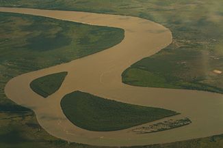
The river has its source at Inyangani in Nyanga National Park 100 km north of Mutare . The river is about 400 km long, 340 km of which are in Mozambique . It drains an area of 31,000 km², 5% of which belongs to Zimbabwe. After the Pungwe Falls, the river flows through a ravine to then tumble down the Mutarazi Falls . In the Honde Valley, a tea-growing area, the Pungwe crosses the border, which it forms for almost 20 km. On its further south-eastern route it takes up some tributaries, especially from the north. At the mouth of the Nhandugue it forms the southern border of the Gorongosa National Park . It reaches a level where it divides into different arms, of which the dingue dingue is the most water-rich and also carries water in the dry season. These arms reunite in front of the bridge over the EN6 trunk road about 100 km before the confluence at Beira . This city supplies the pungwe with drinking water, which is taken before it is divided into different arms.
Hydrology
Only in the immediate headwaters and in the course up to the border do high discharges of up to 1200 mm per year occur in the catchment area of the Pungwe. In the further course of the upper half only too moderate from 200 to 500 mm per year. In the lower half it is only up to 65 mm per year.
The flow rate at about half of the river's catchment area was measured in m³ / s.

Water management
A water tunnel from the Mutarazi Falls to Mutare has been in work since 1997 to ensure the city's drinking water supply in the future. In 2005 the United Nations Development Program started a project to research climate change in the Pungwe catchment area.
Flood
The central and southern coast of Mozambique is relatively flat. In this stretch of coast, cyclones repeatedly hit land. The strong onshore winds and heavy rain in connection with the slight gradient can lead to extreme flood situations during such events.
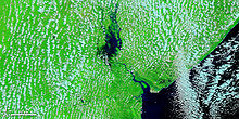
The last time this happened was Cyclone Idai in March 2019. Many of them rain 500 mm a day. An area of over 2000 km² was flooded. It is assumed that there were more than 600 victims in Mozambique. The estimated number of houses destroyed is 230,000.


