Pymatuning reservoir
| Pymatuning reservoir | |||||||||
|---|---|---|---|---|---|---|---|---|---|
| Pymatuning reservoir | |||||||||
|
|||||||||
|
|
|||||||||
| Coordinates | 41 ° 37 ′ 12 ″ N , 80 ° 30 ′ 31 ″ W | ||||||||
| Data on the structure | |||||||||
| Data on the reservoir | |||||||||
| Altitude (at congestion destination ) | 305 m | ||||||||
| Water surface | 69.15 km² | ||||||||
| Reservoir length | 27 km | ||||||||
| Reservoir width | 2.57 km | ||||||||
| Maximum depth | 10.7 m (mean depth 4.6 m) | ||||||||
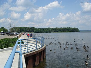
The Pymatuning Reservoir is a reservoir in the US states of Ohio and Pennsylvania . It has a capacity of 64.275 billion gallons in 69.15 km² of water surface. The lake is 27 km long with an average width of 2.57 km, a maximum depth of 10.7 m and a level of 305 meters.
The lake is completely located in two state parks of the same name , the common border of which is identical to the state border. The park area with the body of water amounts to a total of 126 km² of which 30 km² land and 55.5 km² water area are in Pymatuning State Park (Pennsylvania) and 26.8 km² land and 13.65 km² water area are in Pymatuning State Park (Ohio) .
The first inhabitants of the area were the Monongahelas , who left the area for reasons unknown. Two of their mounds lie under the current reservoir. The white settlers had problems with the marshland or lost their cattle in quicksand . Dangerous swamps, floating islands, and the uncertainty of knowing where the land ended and the lake began were commonplace. Bears, mountain lions and foxes had rich prey as predatory game. Mosquitoes that could transmit yellow fever made life even more difficult. A boardwalk should help and make the area passable. Some farmers began to drain individual sections of the marshland to create growing areas for onions.
In 1868 it was discovered through explorations that the entire area could be drained , drained and drained in order to convert it into agricultural land. Farmer hopes were dashed, however, when it was also determined that a dry swamp would destroy the industrial needs of the Beaver Valley and Shenango Valley .
In 1911 it was decided to commission a feasibility study for a dam. In 1913, a flood caused deaths and damage of US $ 3 million. Thereafter, $ 1.2 million was made available by the legislature for a dam. Governor John Tener cut the amount to $ 100,000. It took until 1931 to acquire all of the necessary land and Governor Gifford Pinchot provided $ 1.5 million to build the dam. With the help of 7,000 people, the dam was completed in 1934. The total cost of the construction was $ 3,717,739.
The three main reasons for the construction were a supply of drinking water for industry and households along the Shenango and Beaver Valleys, a retention basin to avoid future flood disasters and the development of a recreational area .
From 1937 to 1971, the Water and Power Resources Board was responsible and then the Department of Environmental Resources , which also set up the Pymatuning State Park. There are bald eagles and numerous water birds on the lake . In the lake live among others Sander vitreous and muskellunge .
References
Web links
- http://www.pymatuning.com/
- http://www.pymatuninglake.com/
- http://www.dnr.state.oh.us/Portals/9/pdf/lakemaps/Pymatuning_Lake.pdf Overview map of the Pymatuning Reservoir (PDF file; 1.34 MB)

