
Queen's Park Savannah

The Queen's Park Savannah (shortened to Savannah in everyday parlance , QPS in the print media ) is a park in Port of Spain . With 110 hectares, it is the largest urban open space in Trinidad and Tobago .
history


What is now Savannah was originally a plantation called Paradise Estate owned by the French-born merchant family Peschier, who migrated from Grenada to Trinidad in 1781 to grow sugar cane. In 1782, under the Cédula de Población, an edict of 1776 to settle Catholic farmers in Trinidad, the Peschiers were awarded land north of the then city limits of Port of Spain by Governor Martín de Salaverría . In August 1817, on the instructions of Governor Ralph Woodford, the city council bought 94 hectares of land from the Peschiers for 6,000 pounds (approx. 550,000 euros today), which was initially called Grand Savannah and was used as an urban pasture and recreational area. When purchasing the area, Woodford had a British-style park in mind, but this was an unusual concept for the established residents of Trinidad. Larger areas of grass were referred to as “sabana” based on an Arawak term in the Spanish language of the former colonial rulers, so that the term “Savannah” was established among the population for the designated “park”. In 1819 the city bought a plot of land from the Hollandais plantation in the north of the Savannah and partially integrated it into the open space. In the middle of the 19th century it was converted into a park. From 1828 until the 1990s, the southern part of the park was used for horse racing; cricket was played in the northern part . In 1837 the Grand Savannah was renamed Queen's Park on the occasion of Queen Victoria 's accession to the throne , but the addition Savannah caught on in the population. In 1854 the "Grand Stand" was built, a stand that has since been renovated several times, from which the horse races and later the carnival parades could be followed. In the second half of the 19th century, the park was used as the island's first golf course, which is special in that it also served as a pasture for cattle. In 1871 the writer Charles Kingsley described the Savannah in his novel At Last: A Christmas in the West Indies and judged the visual presentation of the park against the backdrop of the mountains of the Northern Range that “neither London nor Paris (with such a park) could decorate ”. At the end of the 19th century, the white upper class organized itself into sports clubs. The Queen's Park Savannah Cricket Club was based in the park, as was the Trinidadian polo team, which held “international matches” against other British colonies in the Savannah. In 1896 the cricketers moved to the newly built Queen's Park Oval 500 meters further west. In 1902 the Canadian company Trinidad Electric, which operated large parts of the Trinidadian tram network, installed an excursion train line around the Savannah, which was well received by the residents. From 1913 the Savannah was used as an airfield in the absence of any other suitable area. The first sightseeing flight ended in 1913 with the death of the pilot, the US aviation pioneer Frank Boland. During the Second World War, the government offered the population parcels of the Savannah for free use as arable land to counteract a shortage of imported food caused by the torpedoing of cargo ships by German submarines. Since 1948, the Savannah has been the venue for the annual carnival parades in their current form, which have a competitive character and whose winners have been chosen since 1955 as part of the march along the Grand Stand in the Savannah. Since Trinidad gained independence in 1962, the annual Independence Day parade has been held in the Savannah (except for the years 2007-2009 due to renovations). From 1963 to 2001 the panorama competition was held in the Savannah. The last horse race took place in the Savannah in 1993, as the Trinidad Turf Club relocated to the newly built racecourse in Arima .
Park parts and use
As a permanent installation, the “Grand Stand” is a stand with a view to the north. For large events, a temporary stand with a view to the south will be set up opposite the Grand Stand; this applies primarily to the carnival parades. The south-eastern part of the park is regularly used for open-air concerts; for this purpose, stages adapted to the size of the event are set up and part of the site is fenced off. In the southern half of Savannah is a 600 square meter walled piece of land that is the only privately owned section of the park: the family cemetery of the Peschier family who originally owned the land. There are areas for cricket, soccer and rugby games throughout the park, including 26 cricket and 27 soccer fields; the Schools Girls Rugby League games are played in the Savannah. In the extreme northwest, a section of the park is separated by dense tree cover and designed as a landscape garden. This part called "The Hollows" used to be a water reservoir that was drained and planted; in addition, small ponds were created here. Street vendors sell coconuts and corn on the southern and western fringes of Savannah.
flora
Boundary trees have been planted around the Savannah; some trees grow in the park itself. On tree species are found flame tree , cannon ball tree , coral trees , rain tree , Tabebuia rosea (Pink Poui) and Tabebuia serratifolia (Yellow Poui).
Surroundings
Queen's Park Savannah borders the Downtown district to the north and the Newtown district to the northeast, and thus directly borders the center of Port of Spain. In the west the park borders on the St. Clair district and in the east on Belmont . The border to the region and administrative unit of San Juan-Laventille east of Port of Spain runs through the middle of Queen's Park Savannah. The streets around the park with a total length of 3.7 kilometers are often referred to in Trinidad as the "largest roundabout in the world", but this is not true.
To the north of the park are the Royal Botanic Gardens , the Emperor Valley Zoo and the President's House, the residence and official residence of the President of the Republic. At the western end of the Savannah are the Magnificent Seven , an ensemble of seven extravagantly designed houses built at the beginning of the 20th century. The National Museum and the striking National Academy for the Performing Arts border the park to the south.
gallery

Carnivalists at the Grand Stand

Northern part of the Savannah
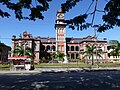
The Queen's Royal College on the western edge of Savannah


Individual evidence
- ^ Anthony de Verteuil: Great Estates of Trinidad . 3. Edition. Litho Press, Port of Spain 2000, ISBN 976-95008-2-8 , pp. 198 .
- ↑ As of 2015, MeasuringWorth.com: Measuring Worth - Purchase Power of the Pound ( Memento from August 13, 2016 in the Internet Archive )
- ^ CitizensforConservationTT.org: Queen's Park Savannah. Retrieved August 7, 2020 .
- ↑ Michael Anthony: Historical Dictionary of Trinidad and Tobago . Scarecrow Press, London 1997, ISBN 0-8108-3173-2 , pp. 462 .
- ↑ Caribbean History Archives: The Queen's Park Savannah. Retrieved May 29, 2016 .
- ↑ Michael Anthony: Historic Landmarks of Port of Spain . Macmillan Caribbean, Oxford 2008, ISBN 978-0-333-97555-8 , pp. 52 .
- ^ Olga J. Mavrogordato: Voices in the Street . Inprint Caribbean, Port of Spain 1977, pp. 63 .
- ^ Gérard A. Besson, Bridget Brereton: The Book of Trinidad . Paria Publishing, Port of Spain 2010, ISBN 978-976-8054-36-4 , pp. 322 .
- ↑ Tramz.com: The trams and trolleybuses of Trinidad & Tobago. Retrieved June 4, 2016 .
- ↑ Michael Anthony: The Making of Port of Spain. Volume 1: 1757-1939 . 2nd Edition. Paria Publishing, Port of Spain 2007, ISBN 978-976-8054-54-8 , pp. 141 .
- ↑ NCICTT.com: Images of Identification. Retrieved June 4, 2016 .
- ↑ NALIS.gov.tt: Carnival. Retrieved May 31, 2016 .
- ↑ NALIS.gov.tt: Independence Day. Retrieved May 31, 2016 .
- ^ John Mendes: Côté ci Côté là . Legacy ed. Caribbean Print Technologies, Port of Spain 2014, ISBN 978-976-8194-06-0 , p. 167 .
- ↑ International School stay perfect . In: Trinidad Express . October 30, 2015.
- ^ T&T rivals Malaysia. In: Trinidad Guardian. November 9, 2014, accessed May 28, 2016 .
Coordinates: 10 ° 40 ′ 9 ″ N , 61 ° 30 ′ 50 ″ W.