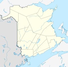
Quispamsis
| Quispamsis | ||
|---|---|---|
| Location in New Brunswick | ||
|
|
||
| State : |
|
|
| Province : | New Brunswick | |
| County: | Kings County | |
| Coordinates : | 45 ° 25 ′ N , 65 ° 57 ′ W | |
| Area : | 57.06 km² | |
| Residents : | 17,655 (as of 2011) | |
| Population density : | 309.4 inhabitants / km² | |
| Time zone : | Atlantic Time ( UTC − 4 ) | |
| Postal code : | E2E | |
| Area code : | +1 506 | |
| Mayor : | Murray Driscoll | |
| Website : | www.quispamsis.ca | |
 town hall |
||
Quispamsis is a city in Kings County in the Canadian province of New Brunswick with 17,655 inhabitants (2011).
geography
Quispamsis is on the east bank of the Kennebecasis River . The connecting roads New Brunswick Route 100 and New Brunswick Route 119 meet in the village . The New Brunswick Route 1 touches the place in the east. Saint John and Hampton are 20 and 15 kilometers to the southwest and northeast, respectively.
history
Originally the area was inhabited by Maliseet Indians . The name Quispamsis means "small lake" in the language of the indigenous people and refers to the nearby Ritchie Lake . Acadians and loyalists settled in around 1783, mainly engaged in agriculture and fishing.
In 1998 the villages of Gondola Point and Wells were incorporated. The inhabitants of the city of Quispamsis, which has grown as a result, are now primarily active in retail, healthcare and service industries.
sons and daughters of the town
- Randy Jones , ice hockey player
Individual evidence
- ↑ Statistics Canada - Census Quispamsis 2011
- ↑ History ( Memento of the original from June 29, 2015 in the Internet Archive ) Info: The archive link was inserted automatically and has not yet been checked. Please check the original and archive link according to the instructions and then remove this notice.
Web links
- historicplaces.ca - St. Luke's Anglican Church
