Río Fortes
|
Río Fortes Río Mayor |
||
|
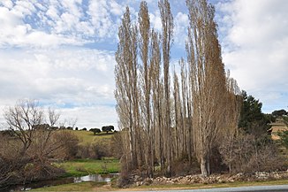
Río Fortes near Mironcillo in the Valle de Amblés |
||
| Data | ||
| location | Avila Province , Spain | |
| River system | Duero | |
| Drain over | Adaja → Duero → Atlantic | |
| source |
Iberian Scheidegebirge 40 ° 29 ′ 32 ″ N , 4 ° 46 ′ 11 ″ W. |
|
| Source height | approx. 1595 msnm | |
| muzzle |
Río Adaja Coordinates: 40 ° 35 ′ 50 " N , 4 ° 48 ′ 7" W 40 ° 35 ′ 50 " N , 4 ° 48 ′ 7" W. |
|
| Mouth height | approx. 1088 msnm | |
| Height difference | approx. 507 m | |
| Bottom slope | approx. 10 ‰ | |
| length | approx. 50 km | |
| Drain |
MQ |
10.9 m³ / s |
| Communities | Riofrío , Mironcillo | |
The Río Fortes is an approx. 50 km long southern tributary of the Río Adaja in the Valle de Amblés in the Spanish province of Avila in the autonomous region of Castile-León .
course
The source of the Río Fortes (still called Río Mayor here ) is located on the north side of the Iberian Divide Mountains ( Sierra de la Paramera ). His path initially leads northwards; at the place Ríofrio he turns to the west to take again a northerly direction at Mironcillo , which he maintains until its confluence with the Río Adaja.
Tributaries
After the snow melts and after heavy rain, numerous streams (arroyos) flow into the Río Mayor and the Río Fortes; however, most of them run out of water in summer and autumn.
Ecosystem
Due to the low population and a correspondingly low agricultural use of the Valle de Amblés , the Río Fortes and its tributaries are only slightly polluted.
Attractions
The churches of Ríofrio and Mironcello are the only places of interest on its banks.
