
Valle de Amblés

The Valle de Amblés is an approximately 500 km² high valley in the north of the Sierra de Gredos and an association of municipalities ( mancomunidad or comarca ) in the center of the Spanish province of Avila in the autonomous region of Castile-León .
location
The now almost deforested high valley of the Valle de Amblés is located north of the Sierra de Gredos mountain range in the province of Ávila at an altitude of around 1000 to 1500 m above sea level. d. M., with all settlements at altitudes between 1050 and 1200 m. The Río Adaja flows in the valley bottom . The historical, cultural and economic center of the region is the city of Ávila in the east of the valley . Despite the rather low rainfall (approx. 450 mm / year), the landscape is criss-crossed by numerous streams (arroyos) and small rivers (ríos) , which, however, regularly dry up in summer and early autumn.
Communities


The community association (comarca) consists of 23 municipios with around 15 hamlets and a total of almost 5,000 inhabitants. The sometimes dramatic population decline since the 1950s is mainly due to the mechanization of agriculture and the associated loss of jobs.
| local community | Height above M. | Area km² | Population 1900 | Population 1950 | Residents 2017 |
|---|---|---|---|---|---|
| Amavida | 1165 | 15.0 | 472 | 527 | 139 |
| El Fresno | 1075 | 12.6 | 381 | 922 | 405 |
| Gemuño | 1100 | 17.1 | 919 | 1,161 | 234 |
| La Colilla | 1130 | 11.3 | 308 | 480 | 328 |
| La Hija de Dios | 1180 | 12.5 | 302 | 421 | 81 |
| La Serrada (Avila) | 1105 | 7.3 | 309 | 301 | 117 |
| La Torre (Avila) | 1130 | 11.4 | 447 | 376 | 246 |
| Mironcillo | 1125 | 15.2 | 293 | 468 | 93 |
| Muñana | 1170 | 33.6 | 849 | 1,079 | 408 |
| Muñogalindo | 1130 | 18.8 | 680 | 725 | 343 |
| Muñopepe | 1120 | 6.0 | 142 | 165 | 106 |
| Muñotello | 1170 | 19.0 | 594 | 582 | 63 |
| Niharra | 1090 | 11.3 | 381 | 366 | 188 |
| Narros del Puerto | 1150 | 10.4 | 320 | 372 | 23 |
| Padiernos | 1100 | 37.0 | 518 | 558 | 269 |
| Poveda (Avila) | 1200 | 7.2 | 217 | 243 | 47 |
| Pradosegar | 1175 | 11.3 | 399 | 520 | 132 |
| Riofrío (Avila) | 1180 | 65.5 | 1,120 | 1,080 | 223 |
| Salobral | 1085 | 7.5 | 244 | 223 | 102 |
| Santa María del Arroyo | 1150 | 11.1 | 232 | 233 | 112 |
| Solo rancho | 1125 | 52.0 | 1,207 | 2.023 | 859 |
| Sotalbo | 1155 | 90.5 | 571 | 732 | 237 |
| Villatoro | 1185 | 56.0 | 950 | 668 | 178 |
economy
The traditional self-sufficiency economy on the semi-fertile but poorly rainy soils of the Valle de Amblés is based on a few products: In the past, barley was mainly grown as a staple food , from which no bread , but porridge or soup was made; In addition, there were fruit trees and garden vegetables such as onions , carrots , cabbage, etc. In the 17th / 18th In the 19th century, potatoes were also added. Animal products were eggs, as well as milk , cheese and meat from sheep and goats . Today the cultivation of wheat as well as summer excursion tourism and the rental of holiday homes (casas rurales) play important roles in the economic life of the communities.
history
Bronze or Iron Age settlers left only insignificant traces. The Castro de Ulaca is very likely of Celtic origin . The Romans , Visigoths and Moors cared only marginally about this remote and formerly forested region, which for a long time was only of importance as a passage between Mérida (Emerita Augusta) , Ávila (Obila) , Segovia and Soria ( Numantia ) and probably only from then onwards Middle Ages gradually became permanently settled. The Amblés Valley with around 40 villages was first mentioned in a document in 1250 , but only a few of the places mentioned can be unequivocally associated with today's place names.
Attractions
The most important attraction is the Celtic (perhaps Vettonic ) fortress of Castro de Ulaca in the municipality of Solosancho ; Further mountain fortresses from this period (e.g. Castro de Las Cogotas ) as well as several Celtic animal figures ( verracos ) can be found throughout the area . In the north of the municipality of Solosancho, a “ Roman bridge ”, possibly originating from antiquity, crosses the Río Adaja. The late medieval Castillo de Aunqueospese rises near the town of Mironcillo . Most places only have small churches from the 16th and 17th centuries. Century, to which a mostly small, semi-open south porch ( portico ) was added in the 18th century . The respective nave is often spanned by an artesonado wood beam ceiling with tie rods ; Elaborately carved or painted baroque altarpieces were probably too expensive for many villagers and are therefore rather rare. The only exception is the three-aisled and richly furnished Iglesia de San Miguel Arcángel in Villatoro .

Castro de Ulaca

Verraco in Solosancho

Puente de los Cobos
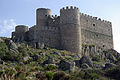
Castillo de Aunqueospese

Church of Amavida

Iglesia de San Miguel Arcángel in Villatoro


