Río Misahuallí
| Río Misahuallí | ||
|
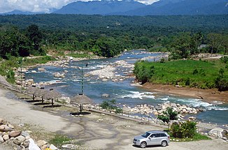
Río Misahuallí near Archidona |
||
| Data | ||
| location | Province of Napo in Ecuador | |
| River system | Amazon | |
| Drain over | Río Napo → Amazon → Atlantic Ocean | |
| Headwaters |
Cordillera Real 0 ° 49 ′ 37 ″ S , 77 ° 56 ′ 17 ″ W. |
|
| Source height | approx. 2250 m | |
| muzzle |
Río Napo near Puerto Misahuallí Coordinates: 1 ° 2 ′ 7 ″ S , 77 ° 39 ′ 51 ″ W 1 ° 2 ′ 7 ″ S , 77 ° 39 ′ 51 ″ W |
|
| Mouth height | approx. 390 m | |
| Height difference | approx. 1860 m | |
| Bottom slope | approx. 27 ‰ | |
| length | 70 km | |
| Catchment area | approx. 1650 km² | |
| Left tributaries | Río Lushan, Río Hollín | |
| Right tributaries | Río Inchillaqui, Río Tena | |
| Medium-sized cities | Tena | |
| Small towns | Archidona | |
| Communities | Puerto Misahuallí | |
The Río Misahuallí is a 70-km-long left tributary of the Napo River in the province of Napo in Ecuador .
River course
The Río Misahuallí has its source in the Cordillera Real at an altitude of about 2250 m . It initially flows 10 km in a north-easterly direction through the mountains. Then it turns almost 20 km to the southeast. He leaves the mountainous country. The Río Misahuallí then flows south through the foothills. He passes the small town of Archidona . At river kilometer 24 it flows along the northeastern edge of the city of Tena and takes the Río Tena on the right. In the lower reaches of the Río Misahuallí flows east. 16 km above the mouth, the Río Hollín , the most important tributary, meets the Río Misahuallí when coming from the north. This finally flows into the Río Napo at the municipality of Puerto Misahuallí .
Catchment area
The Río Misahuallí drains a 70 km long section on the eastern flank of the Cordillera Real. The catchment area is bounded in the south by the river valley of the upper Río Napo and in the north by the Sumaco volcano . The area of the catchment area covers around 1650 km².

