Río Parapetí
| Río Parapetí | ||
|
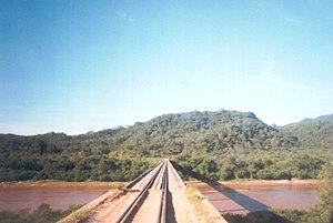
Río Parapetí near San Antonio del Parapetí |
||
| Data | ||
| location | Bolivia | |
| River system | Amazon | |
| source | in the southeastern part of the Bolivian Cordillera Central 18 ° 4 ′ 58 ″ S , 61 ° 43 ′ 42 ″ W |
|
| Source height | 2679 m | |
| muzzle | Bañados de Izozog | |
| Mouth height | about 300 m | |
| Height difference | about 2379 m | |
| Bottom slope | about 4.8 ‰ | |
| length | 500 km | |
| Catchment area | 48,317 km² | |
| Small towns | Camiri | |
| Communities | San Juan del Piraí , San Pablo de Huacareta , Camiri , Choreti , San Antonio del Parapetí | |
The Río Parapetí is a river in the lowlands of the South American Andean state Bolivia .
The source region of the Río Parapetí is located in the southeastern part of the Bolivian Cordillera Central . Since the river only bears its name from the confluence of the Río Azurduy and Río Caraballo , the question of which source of the Parapetí is, has not yet been scientifically clarified. The longest tributary above the confluence is almost 48 km long and has its source at an altitude of 2,679 m on the Tihu Kasa, a peak about 7 km northeast of Torrecillas , the central town of the canton of Las Casas . The Río Parapetí flows from its source for the first 80 km in a largely southerly direction and turns approximately eastward for the next 60 km. Then it flows north to the mouth of the Río Bañado , the following 150 kilometers until it finally leaves the foothills again in an easterly direction, then in a northeastern direction.
Important towns along the river are San Juan del Piraí (km 110), San Pablo de Huacareta (km 140), Camiri and Choreti (km 270), and San Antonio del Parapetí (km 343).
The river has a total length of over 500 km, due to its irregular flow it is not navigable, but is used as a white water route on some passages when the water flow is good. After passing the easternmost foothills of the Cordillera Central, it reaches the Bolivian lowlands of the Gran Chaco and then flows in a north-easterly direction into the wetland of the Bañados de Izozog , where the river gradually seeps away.

