
Rötelstein (Bavaria)
| Red chalk | ||
|---|---|---|
 |
||
| height | 1394 m above sea level NN | |
| location | Bavaria , Germany | |
| Mountains | Bavarian Prealps | |
| Dominance | 1.1 km → Heimgarten | |
| Notch height | 138 m | |
| Coordinates | 47 ° 37 '51 " N , 11 ° 17' 5" E | |
|
||
| Normal way | Marked mountain hiking trail from Ohlstadt or Schlehdorf | |

The Rötelstein is a 1394 m high mountain in the Bavarian Prealps east of Ohlstadt in Bavaria .
The summit can be reached as a simple mountain hike either from Ohlstadt or Schlehdorf. Both routes require some surefootedness in the end.
gallery
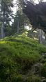
Final ascent over grassy ridges below the summit
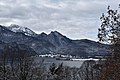
View from Aspenstein to Kochelsee and Rötelstein (middle)

