Röthmoorgraben
| Röthmoorgraben | ||
|
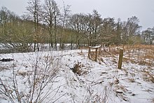
Röthmoorgraben in a park |
||
| Data | ||
| location | Hamburg-Schnelsen | |
| River system | Elbe | |
| Drain over | Kollau → Tarpenbek → Alster → Elbe → North Sea | |
| source | On Farnweg 53 ° 37 '33 " N , 9 ° 55' 19" O |
|
| muzzle | on the border to Hamburg-Niendorf in the Kollau coordinates: 53 ° 37 '15 " N , 9 ° 55' 43" E 53 ° 37 '15 " N , 9 ° 55' 43" E
|
|
| length | 900 m | |
| Big cities | Hamburg | |
| Navigable | No | |
The Röthmoorgraben is an approx. 900 meter long ditch in Hamburg-Schnelsen .
It flows into the Kollau on the border with Hamburg-Niendorf .
It is named after the Röthmoor, where there was a flax rotting area, where the flax was made to break by rotting (red means to rot).
course
It rises on Farnweg west of Röthmoorweg east of the A7 . It runs south and crosses under the Farnweg, turns east at Röthmoorstieg and then runs south-east on a path, then turns east and runs past a park, through a meadow and then flows through a tunnel into the Kollau .
Individual evidence
- ↑ Complete list of rivers in the Elbe catchment area. Retrieved June 30, 2020 .
- ↑ Hamburg, Schnelsen Archive. Retrieved July 27, 2020 .
- ↑ Röthmoorgraben on Google Maps. Retrieved August 5, 2020 .

