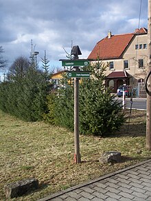
Radeberger circular hiking trail
The Radeberger Rundwanderweg is a local circular hiking trail that circles the town of Radeberg in the Radeberger Land . It crosses the Dresdner Heide and the Landwehr and serves as an important feeder into the Seifersdorfer Valley and the Hüttertal . Its length is about 26 km. The hiker is guided by the green dot mark on a white background. The hiking trail runs over forest and field paths , but also along local connecting roads .
Route
Liegau-Augustusbad ( Grundmühle , following the long distance footpath Lausitz Serpent and the Seifersdorfer Valley) - Kleinwachau - Swan Lake - Feldschlößchen - Landwehr - Stadtrandsiedlung On Taubenberg - Hutberg (296 m) - Wallroda (following the long distance footpath Lausitz Serpent and the Hüttertal) - Kleinwolmsdorf - Bischofsweg (south of Großerkmannsdorf ) - Ullersdorf - Dresdner Heide - Liegau-Augustusbad - Grundmühle
Details
East of the Landwehr, the hiking trail has followed the busy S 95 since the mid-1990s . Since then, the direct route to the Wendensteig north of the suburb is no longer possible due to the construction of a landfill. In 2010, the Radeberg City Council issued a statement on the preliminary draft of the planned S 177 ( Leppersdorf bypass ) to cross under the same. The aim is, through a newly emerging economic way to connect to the previous course.
A paved path leads from the suburban settlement to Wallroda. Here, the trail touches the conservation area Hüttertal. Because of the recreational value and the avifauna of the area, it was placed under protection as early as 1954. The Hüttertal is thus an important local recreation area in the Dresden area. Already at the Wallrodaer Hutberg you can turn towards the Felix Tower (200 meters away) (yellow line). The Radeberg Planetary Trail ends at the Felix Tower with the information board on Pluto .
After the hiking trail has passed the Radeberg district of Ullersdorf, it reaches the extensive wooded area of the Dresden Heath via the Tanzzipfelwiese . Here he follows the historical network of signs. Radeberger Straße can be reached via aisle 2, old 4 and aisle 1. After crossing it, the night wing, the cross and the lower ring follow. The trail leaves the heath via the Liegauer Saugarten and continues to Liegau-Augustusbad.
Individual evidence
- ^ City council printed matter 48/10 of the large district town of Radeberg
- ↑ Internet presence of the Förderverein Hüttertal Radeberg e. V.
- ↑ Description of the Dresden section in the themed city map of the city of Dresden ( Use Rundweg Radeberg as search term .)
Web links
Coordinates: 51 ° 8 ′ 34.3 " N , 13 ° 53 ′ 26.4" E
