
Leppersdorf (Wachau)
|
Leppersdorf
community Wachau
|
|
|---|---|
 |
|
| Height : | 260.5 m |
| Area : | 7.32 km² |
| Residents : | 1058 (Dec. 31, 2010) |
| Population density : | 145 inhabitants / km² |
| Incorporation : | January 1, 1994 |
| Postal code : | 01454 |
| Area code : | 03528 |
Leppersdorf is a district of the municipality of Wachau in the district of Bautzen , Saxony . The district extends over an area of approximately 7.3 km² and has about 1000 inhabitants. Until December 31, 1993 Leppersdorf was an independent municipality . The old communities of Leppersdorf, Seifersdorf and Wachau merged on January 1, 1994 to form the new community of Wachau . Since the name of the Altgemeinde Wachau for the new, by municipality merger resulting community Wachau has been maintained, is today the roll call overlap of the municipality Wachau (with their local council Wachau ) with belonging to this community district Wachau (with their Ortschaftsrat Wachau ). So Leppersdorf is structurally equal footing with the districts Seifersdorf, Lomnitz (on 1 January 1998 incorporated ) and Wachau in the municipality Wachau.
geography
Leppersdorf is a place in East Saxony between Pulsnitz and Radeberg on the state road S 95 , the old post road from Radeberg to Pulsnitz and Camenz . The village on the Kleine Röder with around 1,000 inhabitants is located directly at the Pulsnitz junction with the A4 motorway . The state capital Dresden is about 15 kilometers away. The highest point is the 282.3 m above sea level north of the village . NN high Steinberg .
Leppersdorf borders on the cities of Radeberg, Pulsnitz and Großröhrsdorf , on the municipality of Lichtenberg , on the village of Kleinröhrsdorf , which belongs to Großröhrsdorf, and on the district of Wachau, which belongs to the municipality of Wachau, with its location Feldschlößchen .
Leppersdorf is a so-called two - row forest hoof village . The three-sided farms that still often exist here with adjoining fields (previously: Hufe ) are laid out along the main road that runs through the village. Leppersdorf lies on the edge of the West Lusatia landscape protection area and is largely surrounded by extensive agricultural cultivation areas and isolated contiguous forest areas, including the Landwehr in the southwest and the low forest in the southeast and east of the village.
Development of the population
| year | 1834 | 1871 | 1890 | 1910 | 1925 | 1939 | 1946 | 1950 | 1964 | 1990 | 2010 |
|---|---|---|---|---|---|---|---|---|---|---|---|
| Residents | 694 | 733 | 858 | 1093 | 1095 | 1200 | 1233 | 1355 | 1105 | 853 | 1058 |
coat of arms
Description : In white on a curved green shield base, a green plant with five blue five-petalled flowers.
Symbolism: The plant is common flax (Linum usitatissimum), which indicates the livelihood for crafts and agriculture. Seed flax or flax were an important raw material for line weaving.
history

In 1337 the place of German origin was first mentioned as Luprandisdorf (after the locator name Liutbrand ). The naming was apparently based on the name customary in the Middle Ages for the new settlements after the colonist leaders, presumably Luprand von Sürßen , a ministerial of the Burgraves of Dohna who was documented in three documents from 1309 to 1312 . Further documents from the years 1375 and 1393 tell of Hans, Burgrave of Wittin , who gave Leppersdorf his wife Elisabeth a personal treasure. Leppersdorf emerged as a fishing village due to the very humid and swampy surroundings, because only the surrounding slopes could be used for agriculture. The electoral ponds, which existed in large numbers and were managed by so-called fish masters, were the main source of income for the residents.
During the Thirty Years' War the place suffered severe damage, but in addition to the devastation caused by imperial troops, a raging plague epidemic in 1631 should have displaced most of the residents. On the edge of a forest southeast of the village, a metal cross points to the site of a former plague cemetery from 1584/85.
In the middle of the 19th century, Leppersdorf was predominantly a place characterized by handicrafts and agriculture with around 740 inhabitants, consisting of 32 farms, two water mills and a hereditary court . Many of the local residents also hired themselves as linen weavers . The location on the Alte Poststrasse between Dresden and Kamenz, which has existed since the 18th century, favored rapid development of the place. With the industrialization of Saxony, many residents of the village were employed as construction and industrial workers in the vicinity, especially in the nearby Radeberg with its glass industry.
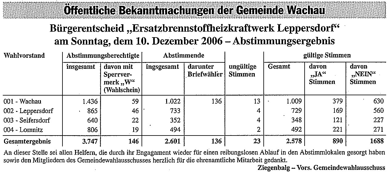
The village was further settled from the 1990s onwards with the construction of the new “Waldblick” development area with single and multi-family houses on the eastern edge of the village. Agriculture is only practiced occasionally. With the settlement of small businesses and the construction of a state-of-the-art milk processing plant, there were fundamental changes within the economic structures of the village. The Sachsenmilch Leppersdorf GmbH dairy plant employs around 2,000 people and has an annual production capacity of around 1.7 billion kilograms of milk. In 2006, the construction of a substitute fuel power plant in the immediate vicinity of the dairy plant was planned to optimize its power supply. However, a referendum in the municipality of Wachau on December 10, 2006 rejected the necessary changes to the development plan for the chosen location with a majority of 65.47% and 2,578 valid votes. In 2007, the "Substitute fuel power plant" project was tackled again by the Müller company. A new location (350 m from the previous one) was chosen for the substitute fuel plant so that the power plant could be built despite the decision. Ultimately, the project was discarded and a gas and steam turbine power plant is now being built on site. There were no major objections to the ongoing approval process.
Worth seeing
Village church


The Leppersdorfer village church , originally a burial chapel, was verifiably built after the Hussite Wars in the 15th century. The simply held by a gable roof with a pointed octagonal roof skylights covered hall building and the east adjacent sacristy are from about 1680, the earthenware, and provided with a Zinnbecken baptismal font of the 1794th
The interior is bordered at the top by a flat, painted field ceiling. The galleries , arranged on three sides, show rural paintings like the early Baroque pews on the parapet fields. The design of the altar and pulpit is based on common motifs, in the middle under a round arch of the altar a crucifixion group and in the predella a scene of the Lord's Supper, as well as a representation of the four evangelists on the pulpit. The bell of the church consists of three bells from the 16th and 17th centuries. The small bell from 1538, the middle bell from around 1500 and the large bell from 1670 with markings (showing vine tendrils and coats of arms) are still in use today. The organ from 1990 has ten registers and is a work by the Bautzen organ manufacturer Hermann Eule , which replaced a previous structure from 1904. The Leppersdorfer Church is a branch church of the Evangelical Lutheran St. Nicolai parish in Pulsnitz.
The granite stone cross on the northern wall of the cemetery is likely to remind of the Hussite Wars or a plague epidemic. In the cemetery there is also a memorial for those who died in the First World War. The sandstone distance column on the state road at the junction to Lichtenberg dates from 1836.
primary school
As early as 1540 Leppersdorf had its own village teacher. The old school building, which was later converted into a residential building, was replaced by the building that is still in use in 1908. At the primary school only pupils from the 1st to the 4th grade are taught, higher-class schools are located in Radeberg.
Other public institutions
- day care center
- Fire station of the Leppersdorf Volunteer Fire Brigade
- Gym
Personalities
- Erich Wirth (1904–1981), lathe operator, Vice President of the Society for German-Soviet Friendship
- Johannes Hörnig (1921–2001), Head of the Science Department in the Central Committee of the SED
literature
- Hans-Werner Gebauer, Manfred Mühlner: Leppersdorf. A chronicle from the beginning to the present. Wachau 2007, ISBN 3-9808371-3-0
- Vincenz Kaiser: From Potschappel to Grafenstein. The Burgraves of Dohna and their ministry between Elbe Valley and Upper Lusatia in the High Middle Ages. In: New Lusatian Magazine . New series Volume 13, 2010, pp. 111-136, especially p. 130
- Dresdner Heide, Pillnitz, Radeberger Land (= values of our homeland . Volume 27). 1st edition. Akademie Verlag, Berlin 1976.
Web links
- www.leppersdorf.de
- www.leppersdorfer.de
- Leppersdorf in the Digital Historical Directory of Saxony
Individual evidence
- ^ HOV ISGV Saxony
- ↑ a b Meilenblätter von Sachsen, 1783, sheet 264. Retrieved on September 9, 2018 .
- ^ Website of the municipality of Wachau and its districts. Retrieved May 24, 2013 .
- ^ Ernst Eichler (Ed.): Historical book of place names of Saxony. Volume I: A-L. Berlin 2001, p. 582
- ^ Leppersdorf in the digital historical place directory. Retrieved May 24, 2013 .
- ^ Friedrich Bernhard Störzner: The Pestkirchhof near Leppersdorf . Legends, historical images and memorable events from Saxony. Contributions to Saxon folklore and local history. In: What the Heimat tells . Verlag Arwed Strauch, Leipzig 1904, p. 194–195 ( What the Heimat tells on Wikisource ).
- ^ Sachsenmilch Leppersdorf GmbH: Sachsenmilch.com . October 28, 2016 ( sachsenmilch.com [accessed July 11, 2017]).
- ↑ Voting result of the referendum. In: The Radeberger. Retrieved May 24, 2013 .
- ↑ Photo of the stone cross
Feldschlößchen | Leppersdorf | Lomnitz | Seifersdorf | Wachau