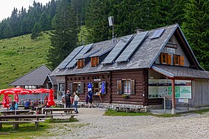
Eisenkappler Hut
| Eisenkappler hut ÖTK hut |
||
|---|---|---|
| location | at the Hochobir ; Carinthia , Austria ; Valley location: Bad Eisenkappel | |
| Mountain range | Karawanken and Bacher Mountains | |
| Geographical location: | 46 ° 30 '6 " N , 14 ° 30' 37" E | |
| Altitude | 1555 m above sea level A. | |
|
|
||
| owner | Eisenkappel section of the ÖTK | |
| Built | from 1950 | |
| Construction type | hut | |
| Development | Asphalted toll road | |
| Web link | Eisenkappler Hut | |
| Hut directory | ÖTK DAV | |
The Eisenkappler Hütte is a shelter of the Eisenkappel section of the ÖTK . It is located at the end of a private road that is subject to tolls and is owned by a section on Hochobir . The most important tour destination is the Obir summit, which can be reached in about two hours with a slight incline.
The hut is located at the intersection of two Austrian long-distance hiking trails , the Südalpenweg and the Eisenwurzenweg .
history
The Eisenkappler Hut was built between 1951 and 1954 through the joint efforts of the Section and the Eisenkappler Mountain Rescue Service . It was created as the successor to the Rainer refuge located just below the summit .
Rainer shelter
The Rainer protection house was a former Knapp home of local lead mining, the trades gave Viktor Rainer the section following the closure of mining. The hut housed the highest meteorological station in the monarchy until the Zittelhaus was built in 1886 , for which a telegraph line was built in 1882. In 1891 the measuring station was expanded to include the Hannwarte on the Obir summit. In 1908 the hut was expanded. In 1944 the hut, which was used by the Wehrmacht as an air defense observation post during World War II , was cremated by partisans .
The Gazebo (1888)
Remnants of the telegraph line (2020)
Individual evidence
- ↑ a b Andreas Klaura: The high Obir over the course of three centuries. September 28, 2004, accessed May 5, 2011 .


