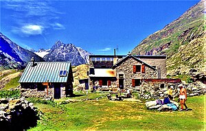
Refuge de la Lavey
| Refuge de la Lavey CAF hut |
||
|---|---|---|
| location | Saint-Christophe-en-Oisans ; Auvergne-Rhône-Alpes , France ; Valley location: Vénéon | |
| Mountain range | Pelvoux | |
| Geographical location: | 44 ° 53 '54.9 " N , 6 ° 12' 22.2" E | |
| Altitude | 1797 m | |
|
|
||
| owner | Club Alpin Français Isère section | |
| Construction type | hut | |
| accommodation | 45 beds, 0 camps | |
| Winter room | 20 bearings | |
The Refuge de la Lavey is a mountain hut in France in Pelvoux in the municipality of Saint-Christophe-en-Oisans , on the edge of the Vallon de la Lavey ( German Valley of the Lavey ). The Ruisseau de la Muande flows north in this valley before finally flowing into the Vénéon valley .
In 1949 the Isère section of the Club Alpin Français bought two buildings in the hamlet of Lavey. The refuge was redesigned in 1949, increased by one floor and expanded in 1972. In winter 2011, the hut narrowly escaped a landslide.
The hut is managed by the Isère Departmental Committee .
From the road from Saint-Christophe-en-Oisans to La Bérarde , a path leads to the refuge just before the hamlet of Champhorent. You have to cross both the Vénéon and the Ruisseau de la Muande on two stone bridges. The difference in altitude on this path is 380 m and takes about two hours to walk.
activities
From the hut you can reach Lac des Bèches , Lac des Rouies , Lac de la Muande and Lac de Fétoules . It also serves as a starting point for tours to the Brêche de l'Olan (from there you can descend to Valjouffrey ), the Col de la Lavey , the Tête des Fétoules and Les Rouies .
Web links
- FFCAM.fr: Refuge de la Lavey (French)
- Hut side: Refuge de la Lavey (French)
- Camptocamp.org: Refuge de la Lavey (French)
- Refuges.info: Refuge de la Lavey (French)
- Skitour.fr: Refuge de la Lavey (French)

