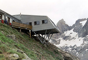
Refuge de la Selle
| Refuge de la Selle STD hut |
||
|---|---|---|
| location | Isère department ; Auvergne-Rhône-Alpes , France ; Valley location: Saint-Christophe-en-Oisans | |
| Mountain range | Pelvoux | |
| Geographical location: | 44 ° 58 '57 " N , 6 ° 14' 56" E | |
| Altitude | 2673 m | |
|
|
||
| owner | Société des Touristes du Dauphiné | |
| Built | 1878, 1934, 1948, 1970 and 1995-1997 | |
| Construction type | hut | |
| Usual opening times | Early April to mid May and June to September | |
| accommodation | 0 beds, 75 camps | |
| Winter room | 16 bearings | |
The Refuge de la Selle is a refuge in Pelvoux , in the Devil's Valley , overlooking the Vénéon Valley .
Accesses
The hut can be reached via a path from the hamlet of Prés (1639 m, parish of Saint-Christophe-en-Oisans ) via the Devil's Valley.
history
The Société des Touristes du Dauphiné built a first stone hut with 10 places in 1878. It was replaced in 1934 by a new refuge with 16 places, which is now used as winter accommodation. An outbuilding is added in 1948. The current hut was built in 1970 and expanded from 1995–1997.
Surrounding peaks
- Col du Replat , can be climbed from the north and south sides
- Le Râteau , west and east peaks
- Col de la Lauze
- Pointe Thorant
- Pointe d'Amont
Web links
- Section: Refuge de la Selle (French)
- Hut side: Refuge de la Selle (French)
- Camptocamp.org: Refuge de la Selle (French)
- Refuges.info: Refuge de la Selle (French)
- Skitour.fr: Refuge de la Selle (French)
Individual evidence
- ↑ Brève histoire des quatre refuges de la selle. (History of the STD huts). Société des Touristes du Dauphiné, accessed on October 7, 2019 (French).

