Rekong Peo
| Rekong Peo | ||
|---|---|---|
|
|
||
| State : |
|
|
| State : | Himachal Pradesh | |
| District : | Kinnaur | |
| Location : | 31 ° 32 ′ N , 78 ° 16 ′ E | |
| Height : | 2315 m | |
| Residents : | 2,397 (2011) | |
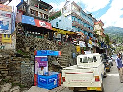
Rekong Peo (also Reckong Peo ) is a large village ( Village ) in the state of Himachal Pradesh and the administrative headquarters of the Indian district Kinnaur .
Rekong Peo is at an altitude of 2315 m and lies at the lower end of the extensive, populated and cultivated slopes of the traditional main town Kalpa , 260 km from Shimla and seven kilometers above the town of Powari on the right bank of the Satluj . In the 2011 census the population was 2397. The NH 22 road runs through the Satluj river valley past Rekong Peo. The nearest major airport is in Chandigarh, 335 km (road kilometers) away .
climate
The climate in Rekong Peo is warm and temperate . The average annual precipitation is 797 mm. The annual mean temperature is 12.8 ° C.
| Rekong Peo | ||||||||||||||||||||||||||||||||||||||||||||||||
|---|---|---|---|---|---|---|---|---|---|---|---|---|---|---|---|---|---|---|---|---|---|---|---|---|---|---|---|---|---|---|---|---|---|---|---|---|---|---|---|---|---|---|---|---|---|---|---|---|
| Climate diagram | ||||||||||||||||||||||||||||||||||||||||||||||||
| ||||||||||||||||||||||||||||||||||||||||||||||||
Web links
Commons : Rekong Peo - collection of images, videos and audio files

