Rhondda
Rhondda , also Rhondda Valley ( Welsh Cwm Rhondda [ kʊm ˈr̥ɔnða ]), is a former mining area in South Wales . In the second half of the 19th century it was one of the largest coal fields in the world, the name is synonymous with coal mining in the South Wales Valleys .
geography
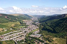
Rhondda consists of two parallel river valleys, the southern Rhondda Fawr (English Great Rhondda ) and the northern Rhondda Fach (English Little Rhondda ). The two valleys are north of Cardiff in the Glamorgan Mountains . The narrow and deeply cut valleys are each about 25 km long and run in a south-easterly direction between Aberdare and Rhondda , until the two valleys merge at Porth . About five kilometers east of the River Rhondda flows into the River Taff at Pontypridd .
The landscape was significantly changed by the mining and the resulting spoil heaps . Numerous miners' settlements sprang up in the valleys, stretching out in long rows of small terraced houses along the mountain slopes. The partly merging settlements in the Rhondda Fawr include Trealaw , Tonypandy , Treorchy and Treherbert , in the Rhondda Fach are Wattstown and Ferndale , at an altitude of 300 m , the highest town in Rhondda.
history
In the Middle Ages, Rhondda was part of the rural community of Ystradyfodwg . Coal was already being mined in the area for local use in the 17th century, but in 1807 Rhondda was still considered a sparsely populated, idyllic mountain valley. In 1812 the first mine was opened in Porth with Dinas . From the mid-19th century, the area became the focus of Welsh coal mining. In 1869 more than 1 million t of coal was mined for the first time, in 1890 production reached 7 million t, half of the coal mined annually in South Wales was mined in Rhondda. The peak was reached in 1913, when 9.5 million tons of coal were mined in 66 mines per year. Most of the coal was transported on the Taff Vale Railway, which was expanded in sections in the middle of the 19th century, to Barry and Cardiff or through the Afan Valley to Port Talbot and exported from there. Due to mining, the population increased extremely due to immigration. While fewer than 1,000 people lived in the valleys at the beginning of the 19th century, the population rose to 169,000 by 1924. The harsh and dangerous working conditions in the mines led to unrest among the miners on several occasions. a. on the Tonypandy uprising of 1910.
The decline of mining began after the First and accelerated after the Second World War, the last mine, Maerdy in the Upper Rhondda Fach, closed in 1990. Most of the mines' above-ground facilities were dismantled, today reminiscent of the industrial past of the Rhondda Heritage Park , which former Lewis Merthyr Colliery, at Porth. Since the end of mining, the area has undergone profound structural change. The population fell to 59,602 inhabitants (2001). Large sections of the valleys have now been reforested, the heaps overgrown with heather.
Politically, Rhondda belonged to Glamorgan until 1974. In 1974 it became one of six districts of the newly formed Preserved County West Glamorgan , and since 1996 it has been part of the County Borough of Rhondda Cynon Taf .
literature
- Evan David Lewis: The Rhondda Valleys. A study in industrial development, 1800 to the present day. Phoenix House, London 1959
Web links
Individual evidence
- ^ Rhondda Cynon Taf: Towns and Villages. Ferndale. (No longer available online.) Archived from the original on September 1, 2015 ; Retrieved September 9, 2015 . Info: The archive link was inserted automatically and has not yet been checked. Please check the original and archive link according to the instructions and then remove this notice.
- ^ Rhondda Valley website: About the Valleys. Retrieved September 9, 2015 .
- ^ Wales Underground: The Rhondda Heritage Park: History and Archeology. Retrieved September 9, 2015 .
- ↑ Rhondda Cynon Taf: History and Heritage in Rhondda Cynon Taf. (No longer available online.) Archived from the original on September 18, 2015 ; Retrieved September 9, 2015 . Info: The archive link was inserted automatically and has not yet been checked. Please check the original and archive link according to the instructions and then remove this notice.
Coordinates: 51 ° 38 ′ N , 3 ° 28 ′ W


