Rif (mountain range)
| Rif
جبال الريف
ⵉⴷⵓⵔⴰⵔ ⵏ ⴰⵔⵔⵉⴼ |
||
|---|---|---|
|
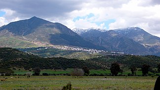
Rifgebirge with Chefchauen |
||
| Highest peak | Jbel Tidirhine ( 2448 m ) | |
| part of | Atlas Mountains | |
|
|
||
| Coordinates | 35 ° 0 ′ N , 4 ° 0 ′ W | |

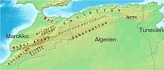
The Rif (also Er Rif ; Arabic جبال الريف, DMG Ǧibāl ar-Rīf , Tarifit ⵉⴷⵓⵔⴰⵔ ⵏ ⴰⵔⵔⵉⴼ Idurar n Arrif ) is a mountain range of about 350 kilometers in Morocco belonging to the Atlas Mountains in North Africa .
location
The Rifgebirge borders directly on the Mediterranean in the north ; it forms the African promontory to the Strait of Gibraltar and culminates there in Jbel Musa , which is opposite the Rock of Gibraltar on the Iberian Peninsula . To the south it is replaced by the mountain ranges of the Middle Atlas and the Tell Atlas .
population
The Rif Mountains are not very heavily populated, but if you include the cities of Tangier with around 620,000 inhabitants and Tétouan with around 320,000 inhabitants (2004), things look a little different. The largest city in the Rif Mountains themselves is Chefchaouen with around 40,000 inhabitants. A large part of the population consists of Berber Rifkabyls who speak Tarifit and also often speak Moroccan Arabic . The highest elevation of the Rif Mountains is the Jbel Tidirhine at 2448 m .
economy
For centuries, the inhabitants of the rugged Rif Mountains lived in a kind of self-sufficiency economy . Grains (wheat, barley, millet, etc.) and vegetables (potatoes, broad beans, carrots, melons, etc.) were grown. The improved transport options during and after the colonial era meant that more distant markets could be supplied. Morocco is also the world's largest exporter of hashish . The hemp plants are mainly grown in the Rif Mountains east of Chefchaouen with the center around Issaguen (formerly Ketama ).
history
In 1912 the northern slopes of the mountains fell under Spanish protectorate, but the Spanish could only expand their influence along the Mediterranean coast; in the years 1921 to 1926, Abd al-Karim established the independent Rif republic instead .
Web links
Individual evidence
- ↑ The altitude information varies by around 10 m depending on the source.
- ↑ James Ketterer: Networks of Discontent in Northern Morocco - Drugs, Opposition and Urban Unrest. (PDF; 1.4 MB) Middle East Report 218, spring 2001.


