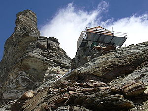
Rifugio Jean-Antoine Carrel
| Rifugio Jean-Antoine Carrel Refuge Jean-Antoine Carrel |
||
|---|---|---|
|
The Jean-Antoine Carrel refuge . |
||
| Mountain range | Valais Alps | |
| Geographical location: | 45 ° 58 '23 " N , 7 ° 38' 51" E | |
| Altitude | 3830 m slm | |
|
|
||
| owner | Italian Matterhorn Mountain Guide Association ( Società Guide del Cervino / Société des guides du Cervin ) | |
| Built | 1969 | |
| Construction type | hut | |
| Usual opening times | all year round, but not managed | |
| accommodation | 50 beds, 0 camps | |
The Rifugio Jean-Antoine Carrel (Italian) Refuge Jean-Antoine Carrel (French) is a refuge in the Aosta Valley in the Valais Alps . It is located at an altitude of 3830 m in the Valtournenche valley on the Lion Ridge (French Arête du lion ) of the Matterhorn within the municipality of Valtournenche . The hut is not managed, but is open all year round and offers 50 mountaineers sleeping places during this time. It is on the normal Italian route to the Matterhorn.
Ascent
The ascent to the hut begins in Breuil-Cervinia and first leads to the Duca degli Abruzzi refuge , which you pass after around 1¾ hours. After another 4¼ and a total of 6 hours you finally reach the Carrel refuge on a challenging path in the final ascent (difficulty D).
history
As early as 1905, the Luigi Amedeo di Savoia bivouac was built not far from where it is today . The origins of today's hut go back to 1969. This building was expanded in the years 2002–2003 and has been in the same condition as it is today. The hut was dedicated to the climber Jean-Antoine Carrel .
The old Luigi Amedeo di Savoia bivouac now serves as a museum, office and emergency shelter.
Tour possibilities
Summit tours
The hut is used almost exclusively for climbing the 4478 m high Matterhorn over the Lion ridge.


