Riggs Peak
| Riggs Peak | ||
|---|---|---|
|
Riggs Peak (center) |
||
| height | 1690 m | |
| location | Smith Island , South Shetland Islands | |
| Mountains | Imeon Range | |
| Coordinates | 63 ° 2 '14 " S , 62 ° 36' 54" W | |
|
|
||
|
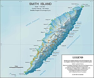
Map of Smith Island with Riggs Peak (below center) |
||
The Riggs Peak (English; Bulgarian връх Ригс wrach Rigs ) is a 1690 m high mountain on Smith Island in the archipelago of the South Shetland Islands . In the Imeon Range, it rises 2.1 km southwest of Neofit Peak , 5 km southwest of Mount Foster and 8.5 km northeast of Cape James . The Letniza Glacier is south, the Gramada Glacier is east and southeast of it.
Bulgarian scholars mapped it in 2008. The Bulgarian Commission for Antarctic Geographical Names named it in the same year after the US missionary and linguist Elias Riggs (1810-1901), who was responsible for organizing the translation, printing and distribution of the Bible in Bulgaria had contributed significantly to the Bulgarian rebirth .
Web links
- Riggs Peak in the Composite Gazetteer of Antarctica (English)


